WILLISTOWN CONSERVATION TRUST

  • Facebook
  • Instagram
  • LinkedIn
  • YouTube
DONATE
  • About
    • HOW WE WORK
    • WHERE WE WORK
    • OUR STAFF AND TRUSTEES
    • JOBS & INTERNSHIPS
    • VOLUNTEER
    • RUSHTON CONSERVATION CENTER
    • STRATEGIC PLAN
    • DIVERSITY, EQUITY & INCLUSION STATEMENT
    • FAQs
  • LATEST
    • BLOG
    • IN THE NEWS
    • PUBLICATIONS
    • PHOTOS
  • PROGRAMS
    • BIRD CONSERVATION
    • COMMUNITY FARM
    • EDUCATION
    • LAND PROTECTION
    • STEWARDSHIP
    • WATERSHED PROTECTION
  • NATURE PRESERVES
    • ASHBRIDGE PRESERVE
    • HARTMAN MEADOW
    • KESTREL HILL PRESERVE
    • KIRKWOOD PRESERVE
    • RUSHTON WOODS PRESERVE
  • EVENTS
    • EVENT CALENDAR
    • BARNS & BBQ
    • RUN-A-MUCK
    • WILDFLOWER WEEK
    • ECOCENTRIC EXPERIENCE
    • RUSHTON NATURE KEEPERS (RNK)
    • ACCESS Program
  • Support
    • WAYS TO GIVE
    • SPONSOR THE TRUST
    • CORPORATE PARTNERSHIP PROGRAM
    • JOIN THE SYCAMORE SOCIETY
    • LEGACY SOCIETY & PLANNED GIVING
    • DELCO Gives 2025
  • CAMPAIGN FOR KESTREL HILL PRESERVE

Rushton Woods Preserve Improvements: A Bioretention Basin, New Trails, and More to Come

March 27, 2023 By Andrew Kirkpatrick

By Andrew Kirkpatrick, Director of Stewardship

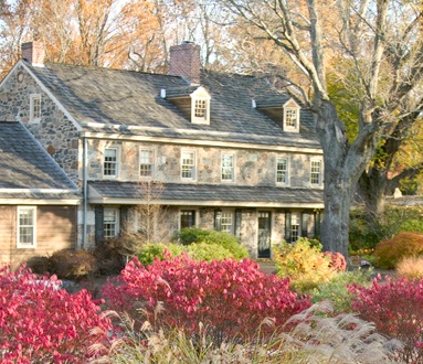
If you’ve recently been out to Rushton Woods Preserve, you likely noticed some new plantings, closed trails due to maintenance, and extra noise from various machinery. For the last year, we’ve been busy at work at Rushton, and we’re pleased to report on the many projects that will help make Rushton Woods Preserve an even better experience for all!

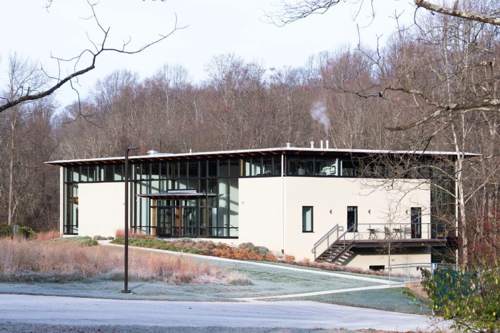
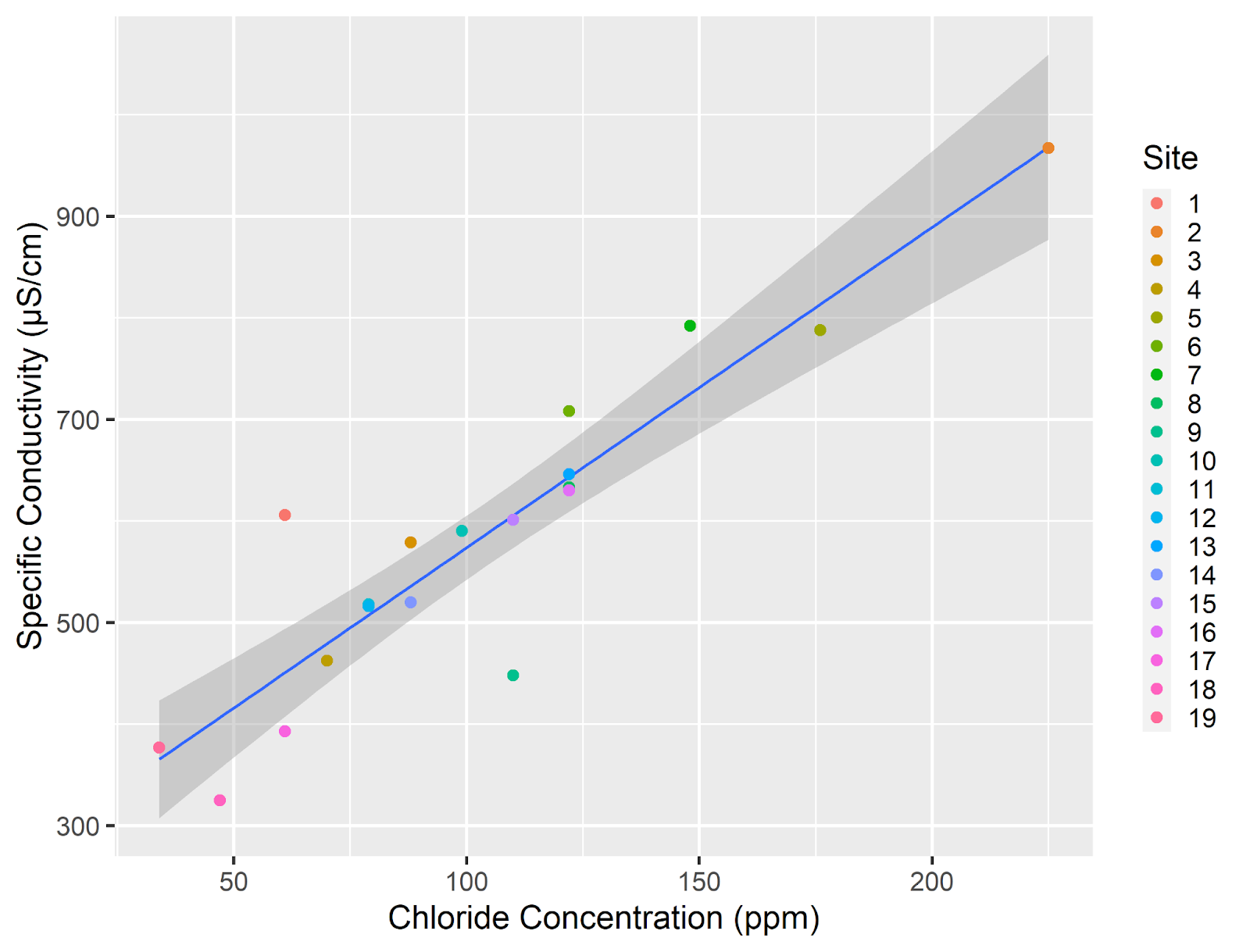
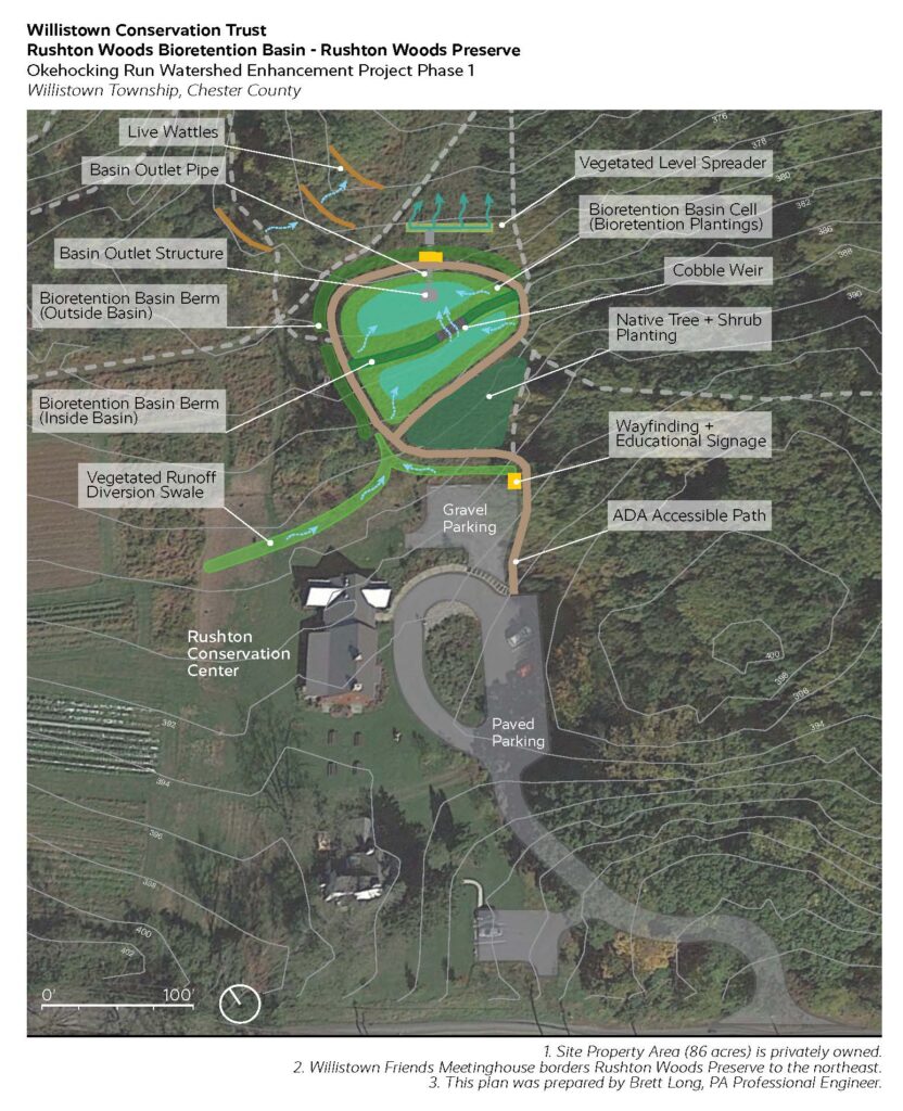
This year, WCT received a grant from the PA Department of Environmental Protection’s Growing Greener program that — combined with funding from PA Department of Conservation and Natural Resource’s C2P2 program — will pay for the design and construction of a half-acre bioretention basin with a perimeter ADA path in the field below the Rushton Conservation Center.

A bioretention basin is a green stormwater infrastructure improvement that slows down runoff and contains it behind berms filled with native plants. The stormwater collects and infiltrates slowly into the ground rather than flowing across the surface, which reduces erosion and downstream sedimentation.

The new basin, which will be constructed next year, will also provide more habitat for pollinators and birds. Filled with a variety of native plant species that tolerate periods of wetness, the basin will demonstrate to the public the benefits of combining habitat improvements with stormwater management strategies.

This spring we will construct an ADA path to connect the Rushton Conservation Center to the farm shed. This new path will provide a safe and durable surface for users of all abilities to enjoy the views of the farm and preserve. As part of the project, we will also be restoring a section of the hedgerow with native shrubs that support birds with high quality food and nesting. The project is funded by grants from Chester County and PA DCNR.

At the end of last year, we finished a trail project through the main corridor in Rushton Woods that improved the surface and stability of the trail for pedestrians and equestrians. Green Roots Inc. worked throughout an unusually wet fall and winter to lay fabric and stone aggregate to create the new tread surface. They also installed pipes underneath the trail to improve overall drainage throughout the corridor.

This was the first phase of an overall plan to improve trails at the Preserve for visitor enjoyment, safety, and accessibility. Most of the trails at Rushton were never properly designed or sited, but are the remnants of a legacy of equestrian use and fox hunting. Where the fox went, the horses followed, and thus, a trail was born. Now with the help of grant funding, we are improving our trails to deal with the increasingly intense storms resulting from climate change. Taking action now will ensure their long-term viability and accessibility for years to come.

We identified all of these projects during our Master Planning process that looked at the ecological and cultural resources at the Preserve. We then developed plans to improve these resources and amenities while increasing their sustainability and resilience for future generations.

For now, we hope you’ll spend some time exploring these new trails at Rushton Woods Preserve! See you in the woods.

Filed Under: Nature Preserves, Stewardship, Trails, Tree Planting, Volunteers

Meet our Corporate Partner: Veritable

March 27, 2023 By Communications Team

By Wesley Yamamoto, Veritable Partner

With a long-shared history of preserving the natural beauty and fostering a sense of community in Willistown, Veritable is proud to be the inaugural corporate partner of Willistown Conservation Trust.

Over 37 years ago, Veritable was founded by Michael Stolper, a University of Pennsylvania ornithology major turned investment industry entrepreneur. He set out to create a new model in the investment business that was free from the traditional conflicts of the industry and better aligned his goals and values with those of his clients. The principles of independence, client advocacy, and intrepid innovation resonated with successful families in the Philadelphia area, the northeastern United States, and soon across the country. Today, Veritable proudly serves as investment advisor and family office to over 225 clients and their collective $17+ billion in assets under management. Veritable is now one of the largest, independent investment advisory firms in the nation with clients in over 35 states. However, Willistown remains home to its national headquarters and many employees.

In the firm’s early years, Michael sought out new office space to house his rapidly growing team. Counter to the conventional approach of a financial firm renting a downtown office in Philadelphia or New York City, Veritable — then known as Stolper and Co. — embraced the idea that independence from the traditional bank and brokerage model environment could extend beyond a business model to the firm’s actual physical presence as well. In 1992, the firm found its permanent home at 6022 West Chester Pike: a 22-acre campus featuring a turn-of-the-19th century farmhouse backed up by hilly woodlands.

Veritable’s Farmhouse Office
“Farside,” Veritable’s newest expansion to their office

As the plans for the farmhouse office conversion were drafted, Veritable’s relationship with Willistown Conservation Trust officially commenced. Michael made the decision to ease 10 acres of Veritable’s campus in perpetuity with WCT. For over 30 years now, Veritable and Willistown Conservation Trust have only strengthened ties. Many of the firm’s 80+ employees have embraced and frequently participated in WCT’s programs and offerings. Some highlights cited by partners and staff were: Northern saw-whet owl banding, hiking and exercising in the preserved lands, the CSA program, and the lecture series. Beyond Veritable’s corporate support over these many years, several senior investment team members at Veritable have served in official and unofficial capacities at the WCT. Of note, former board member Matt Taylor is an investment team leader and partner at Veritable. He served on the finance committee of the WCT for several years. Current board member Justin Thompson is a senior member of the investment team at Veritable. He succeeds Matt as current Chair of WCT Finance Committee, and he serves as Co-Chair of Run-A-Muck.

Across Veritable’s staff and leadership, there is a palpable appreciation for nature and the importance of sustainability. As the firm approaches its 40th anniversary, it continues to invest in its people and its business here in Willistown. With a campus adjacent to preserved lands and supported by a close-knit community of stewards, the firm’s investments are always made with intention. For Veritable, there is no starker example of both the time that has passed and the commitment that remains than the newest expansion to the office. A geothermally heated, 10,000 square foot, modern office building equipped with floor to ceiling windows for employees and visiting clients to forest bathe and birdwatch as they go about their business.

To learn more about Veritable’s services visit veritablelp.com.

Interested in becoming a Corporate Partner?

When you participate in WCT’s Corporate Partnership Program, not only do you receive exposure and recognition among our broad network of supporters and visitors, but you are also given direct access to nature. Choose from our three Corporate Partnership Levels — PRESERVE PARTNER ($25,000), PROGRAM PARTNER ($10,000) and COMMUNITY PARTNER ($5,000) — to enrich your employees’ lives, support local science, and make a far-reaching environmental impact. Learn more about our Corporate Partnership Program here.

Filed Under: General, Volunteers

Insights from Two Years of Community Science Monitoring in Darby Creek

March 27, 2023 By Anna Willig

By Anna Willig, Watershed Conservation Research and Data Specialist

This March, the Darby Creek Community Science Monitoring Program (DCCS) — a collaboration between Willistown Conservation Trust, Darby Creek Valley Association, and Stroud Water Research Center — celebrated its second birthday! We officially launched the DCCS in March 2021 with two stalwart volunteers sampling at two sites in Berwyn. Today, 28 volunteers actively monitor 21 sample sites throughout the watershed, extending past Folcroft (Figure 1). The goals of the DCCS are to learn about the health of Darby Creek and its tributaries and identify key restoration sites through monthly water quality monitoring visits.

Figure 1

Water temperature is a key indicator of stream health. As water warms, it holds less oxygen and becomes inhospitable to aquatic wildlife. Trout fishes are one of the most sensitive groups to high water temperature and are a benchmark for healthy streams. If streams are too warm for trout, they are likely too warm for a host of other aquatic species, including mussels and macroinvertebrates. Water temperatures in Darby Creek are often too warm to support the reproduction and survival of trout species (Figure 2). The removal of trees along a stream, increases in development, and stormwater runoff can all contribute to warming streams. The best way to cool streams down is by reforesting stream banks, planting native plants, and designing stormwater management that allows rain to soak into the soil.

Another indicator of stream health is chloride concentration. Chloride is an ion that reflects the amount of salt in streams. Road salt is the main source of salt in streams and is increasingly recognized as a major pollutant. Chloride concentration varies widely between sites in Darby Creek (Figure 3). Generally, chloride concentrations are below the chronic exposure threshold set by the EPA, but are above levels that researchers have found harmful to aquatic organisms. While road salt is necessary for safe winter travel, limiting use and sweeping salt up after storms can reduce salt pollution in streams.

While temperature and chloride concentration reflect a host of threats to the health of Darby Creek, our volunteers have found good news in Darby Creek. One volunteer found a small population of freshwater mussels — which are uncommon in Darby Creek — at one sample site. Freshwater mussels are one of the most imperiled groups globally, and finding them in Darby Creek is a clear indicator that, despite development and pollution, the creek is still a critical resource deserving of protection. We are working with research groups to document and protect this precious group of mussels.

Figure 2. Water temperature in Darby Creek. Each dot represents a measurement taken by a volunteer. Each site is individually colored. The black line represents the maximum water temperature that supports the reproduction of trout.
Figure 3. Chloride concentration in Darby Creek. Each dot represents a measurement taken by a volunteer. Each site is individually colored.

We are incredibly grateful to all the fantastic volunteers who participate in this program. Through their dedication and enthusiasm, the DCCS has exceeded all expectations! The heart of this program is partnership, and we are thankful for support from Stroud Water Research Center and Darby Creek Valley Association. As the DCCS enters its third year, we are excited to build on partnerships, gain new insights, and leverage our volunteers’ data to improve the health of Darby Creek.

To learn more about the Darby Creek Community Science Monitoring Program, please visit their website or email Lauren McGrath (lbm@wctrust.org).

Filed Under: Volunteers, Watershed

Capturing a Snapshot of Darby Creek

December 7, 2022 By Anna Willig

By WCT Conservation Research and Data Specialist Anna Willig 

At the beginning of November, the Watershed Protection Program at Willistown Conservation Trust (WCT) partnered with the Darby Creek Valley Watershed Association (DCVA) and, together, enlisted four volunteers to conduct a sampling “blitz” in the Darby Creek Watershed. With the help of our determined volunteers, we collected samples from 19 previously unstudied sites in two hours (Map 1). Once the volunteers collected the samples, everyone met at the Upper Main Line YMCA’s Artisan Village to analyze water quality and discuss the results. 

Our Team (from left to right): Charlie Coulter (volunteer), Anna Willig (WCT, author), Lauren McGrath, Michelle Lampley (UMLY), Deirdre Gordon (volunteer), Lloyd Cole (volunteer), Dale Weaver (volunteer), and Aurora Dizel (DCVA).

Darby Creek originates in small tributaries along the Route 30 corridor from Easttown to Ardmore which flow together as the stream makes its way towards John Heinz National Wildlife Refuge where it meets the Delaware River. Throughout its length, Darby Creek flows through many highly developed areas, picking up road salts, fertilizers, and other pollutants from lawns, parking lots, and roadways. 

Despite these threats to the health of the stream, few community science studies have been completed to understand the health of Darby Creek and all of its tributaries. To shed some light on the water quality in the Darby Creek Watershed, the Darby Creek Community Science Monitoring Program was launched in 2021 in partnership with DCVA and under the scientific guidance of Stroud Water Research Center. To date, volunteers have been trained to collect high quality water chemistry data at 15 sites throughout the entire watershed every four weeks. 

The sampling blitz, which covered 19 sites in the headwaters of Darby Creek, allowed us to gain even more information on water quality while controlling for weather conditions. Rain, heat, and other weather conditions can impact water quality measurements. By sampling at a single point in time, we can capture differences in water quality between sample sites rather than changes caused by time. Many of the sampling sites were located on small tributaries, allowing us to study how fine-scale differences in land use upstream of the sample site can impact water quality. 

One of the goals of the sampling blitz was to understand salt pollution in the headwaters of Darby Creek. Road salts applied in the winter end up in streams as snow and ice melt and flow into the nearest waterway. Salts can build up in groundwater and soils, resulting in long-term increases in salt concentration in streams, a phenomenon known as freshwater salinization. Freshwater salinization is occurring across North America, and increases in salt concentration threaten the fish, insects, mussels, and other organisms living in streams. By measuring salt concentration in November, before winter road salts are applied, we capture baseline concentrations that reflect long-term buildup of salts in soils and groundwater. 

The results of the sampling blitz indicate that salt pollution (as measured by chloride concentration) varied widely across the headwaters of Darby Creek. Chloride concentration ranged from 34 ppm to 230 ppm (Map 1). The lowest chloride concentration was measured at Site 19, a site located on Camp Run, a small tributary to Darby Creek. The area that drains into Camp Run is predominantly agricultural land, with some sections of limited residential development and forest. By contrast, chloride concentration was highest at Site 2, a site on an unnamed tributary. The land that drains into Site 2 is similar to the size of the Camp Run watershed, but is much more developed. The tributary originates near a SEPTA train station and flows under Route 30, picking up salt and contamination from residential and commercial developments. Identifying pollution hotspots, such as Site 2, can help determine areas that should be targeted for future restoration. 

Map 1. Sample sites in the headwaters of Darby Creek. Each point represents the approximate location of a sample site and is colored by the chloride concentration at that site. Low chloride concentrations are represented by pale yellow, with high chloride concentrations represented by a dark red. The red box indicates the sample area.

Another indicator of water quality that volunteers measured was specific conductivity, which reflects how well electricity can move through water. Pure water is a poor conductor and has a low conductivity. As more ions are added to the water — from pollutants such as salts, fertilizers, and heavy metals — conductivity increases. Conductivity also varied greatly between sites, ranging from 325 to 967 μS/cm. While a higher conductivity indicates a higher concentration of pollutants, it does not indicate the type of pollutant. When chloride (which is an ion that increases conductivity) is compared to conductivity at each site, we found that there is a strong relationship between the two measurements (shown by the trendline), indicating that salt pollution is the biggest driver of conductivity in the headwaters of Darby Creek (Figure 1). However, there are two sites, Site 1 and Site 9, that do not quite follow the relationship. Further research is needed to understand what is driving conductivity at these sites. To learn more about conductivity, check out the State of Our Streams Report. 

Figure 1. The relationship between chloride concentration and specific conductivity in the headwaters of Darby Creek. Each point represents a chloride concentration and specific conductivity measurement taken at a sample site. Points are colored by site. 

The results of the snapshot survey indicate that water quality is highly variable in the headwaters of Darby Creek. Sites that drain the highly-developed Route 30 corridor, such as Site 2 and Site 5, have relatively poor water quality, while sites that drain areas with more open space, such as Site 18 and Site 19, have much better water quality. The variability in water quality within a small section of the Darby Creek Watershed highlights the deep connection between local land use and stream health. Protecting areas of open space, especially in small tributaries, is crucial to maintaining and improving water quality throughout the entire watershed. 

Additionally, increasing awareness of threats to water quality, such as winter road salt application, can help to reduce the impact on local streams. To reduce road salt contamination in streams, avoid over applying salt and sweep up any salt that remains after snow and ice have melted. The salt can be reused for the next winter storm, saving money and helping improve water quality! 

This snapshot survey was a pilot for a larger survey WCT, DCVA, and Stroud Water Research Center are hoping to conduct in the spring. We are deeply grateful to the Upper Main Line YMCA for hosting this event and to our fantastic volunteers who were willing and eager to explore new sections of stream to collect this data. The snapshot survey would not have been possible without our partnerships with DCVA and Stroud Water Research Center. If you are interested in joining our community science program, please contact Lauren McGrath at lbm@wctrust.org. 

Filed Under: Conservation, Nature, Science, Volunteers, Watershed

Market in the Meadow Vegetarian Chili Recipe

December 6, 2022 By Communications Team

This recipe comes from What’s Gaby Cooking.
Cover photo by Jennifer Mathes

You all loved our Vegetarian Chili from Market in the Meadow, so we had to share!

A special thanks to our dedicated volunteers who harvested, chopped, and cooked this delicious meal at the Rushton Conservation Center. Most of the ingredients came right from Rushton Farm.

INGREDIENTS

  • 1 tablespoon olive oil, plus 2 extra teaspoons
  • 1 large sweet potato, peeled and diced
  • 1 large red onion, diced
  • 4 cloves garlic, roughly chopped
  • 2 tablespoons chili powder
  • 1/2 teaspoon ground chipotle pepper
  • 1/2 teaspoon ground cumin
  • 1/4 teaspoon kosher salt
  • 3 1/2 cups vegetable stock
  • 1 15-ounce cans black beans, rinsed and drained
  • 1 14.5-ounce can fire roasted diced tomatoes
  • 1/2 cup dried quinoa
  • 4 teaspoons lime juice
  • serving suggestions: avocado, cilantro, crema, grated cheese

DIRECTIONS

  1. Heat a large heavy bottom pot with the oil over medium high heat.
  2. Add the sweet potato and onion and cook for about 5 minutes, until the onion is softened. Add the garlic, chili powder, chipotle, cumin, and salt and stir to combine.
  3. Add the stock, tomatoes, black beans, and quinoa and bring the mixture to a boil. Stir to incorporate.
  4. Cover the pot and reduce the heat to maintain a gentle simmer.
  5. Cook for 30-40 minutes until the quinoa is fully cooked and the sweet potatoes are soft.
  6. Add the lime juice and remove the pot from the heat. Season with salt as needed.
  7. Garnish with avocado, cilantro, crema, or cheese before serving.

Serves 4 people.

This recipe comes from What’s Gaby Cooking.

Filed Under: Rushton Conservation Center, Sustainable Agriculture, Volunteers

  • 1
  • 2
  • 3
  • Next Page »

CONTACT

925 Providence Road
Newtown Square, PA 19073
(610) 353-2562
land@wctrust.org

JOIN OUR MAILING LIST

Copyright © 2025 · WCTRUST.ORG