WILLISTOWN CONSERVATION TRUST

  • Facebook
  • Instagram
  • LinkedIn
  • YouTube
DONATE
  • About
    • HOW WE WORK
    • WHERE WE WORK
    • OUR STAFF AND TRUSTEES
    • JOBS & INTERNSHIPS
    • VOLUNTEER
    • RUSHTON CONSERVATION CENTER
    • STRATEGIC PLAN
    • DIVERSITY, EQUITY & INCLUSION STATEMENT
    • FAQs
  • LATEST
    • BLOG
    • IN THE NEWS
    • PUBLICATIONS
    • PHOTOS
  • PROGRAMS
    • BIRD CONSERVATION
    • COMMUNITY FARM
    • EDUCATION
    • LAND PROTECTION
    • STEWARDSHIP
    • WATERSHED PROTECTION
  • NATURE PRESERVES
    • ASHBRIDGE PRESERVE
    • HARTMAN MEADOW
    • KESTREL HILL PRESERVE
    • KIRKWOOD PRESERVE
    • RUSHTON WOODS PRESERVE
  • EVENTS
    • EVENT CALENDAR
    • BARNS & BBQ
    • RUN-A-MUCK
    • WILDFLOWER WEEK
    • ECOCENTRIC EXPERIENCE
    • RUSHTON NATURE KEEPERS (RNK)
    • ACCESS Program
  • Support
    • WAYS TO GIVE
    • SPONSOR THE TRUST
    • CORPORATE PARTNERSHIP PROGRAM
    • JOIN THE SYCAMORE SOCIETY
    • LEGACY SOCIETY & PLANNED GIVING
  • CAMPAIGN FOR KESTREL HILL PRESERVE

Beavers Beyond the Dam

June 22, 2022 By Watershed Protection Team

By Watershed Protection Program Co-Op Catherine Quinn

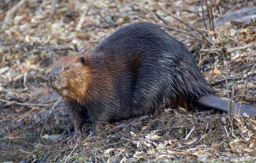
Beavers are known and loved as one of North America’s favorite stream architects. With historic removals of these lovely creatures, we are only just now grasping how important they are in shaping our freshwater ecosystems, which encompasses all streams, rivers, lakes, and ponds, as well as the surrounding land. In food chains, removing any level will alter populations of other levels. For instance, if a species of fish is removed from a stream, populations of macro-invertebrates (which are aquatic, typically early development forms of insects) will grow as there are fewer predators to keep their populations in check. In turn, with large numbers of macro-invertebrates, algae will decrease in population size as there is a higher demand for them as food.

Beaver by Andrew Patrick

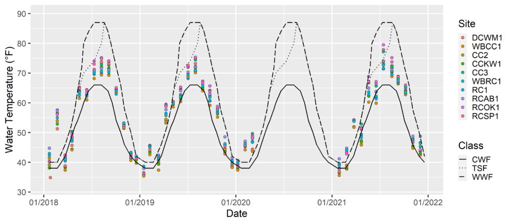
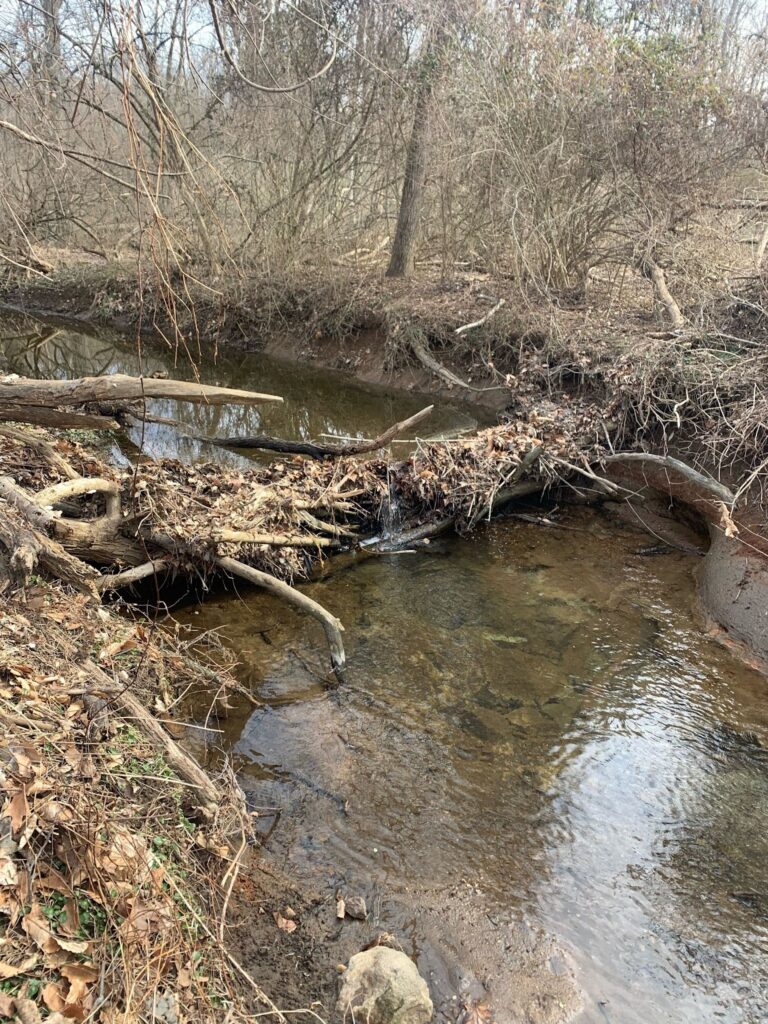
With beavers, their impact extends beyond these food chain alterations when they are introduced to a new stream ecosystem. As ecosystem engineers, beavers actively change the physical features of freshwater environments by building their dams. Even failed or abandoned dams continue to affect the environment. Dams are incredibly capable of storing nutrients and groundwater. They affect water flow to varying degrees and can alter water temperatures. These alterations of physical qualities change the quality of life for other organisms. For example, certain organisms rely on food flowing straight into their mouth, habitat, or home and therefore thrive in fast-flowing areas of water. If that water slows down, they may not be able to survive!

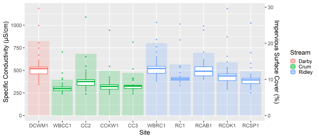
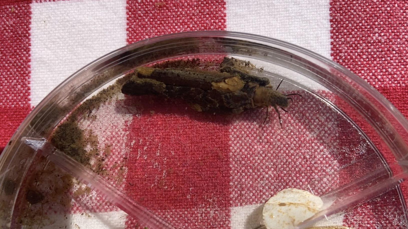
In terms of understanding our streams, we already have a considerable grasp of the macro-invertebrates that inhabit them. Freshwater macro-invertebrates typically live on rocks in fast-flowing environments, like streams. They play an integral role in food chains as they consume much of the plant matter in streams and are an excellent food source for predators, both in water and on land. With the introduction of a significant change to an ecosystem, such as a beaver dam, the conditions macro-invertebrates are used to may be impacted, which will either improve or worsen their ability to survive and reproduce in the environment.

Beaver Dam by WCT Watershed Protection Program

Macro-invertebrates play an important role in regulating nutrients as they enter and leave the water. They are also incredible bioindicators, meaning their presence alone can tell us about the health of the water they are living in. Each macro-invertebrate lies on a scale of pollution tolerance, from sensitive to tolerant. In healthy freshwater systems, we see sensitive groups and a variety of species. This biodiversity tells us that the ecosystem is healthy enough to keep the maximum number of organisms happy. With this application of macro-invertebrates, we can use them to understand how beaver dams are affecting freshwater systems entirely.

The jury is still out on how beaver dams impact the existence of macro-invertebrates, but one thing is certain: beaver dams are indeed affecting them. One study by Clifford et al. (1983), found that in an Alberta, Canada stream, macro-invertebrates increased in both abundance (the number of species) and biodiversity (the variety of species) after the introduction of beavers. The study concluded that sections of the stream flowing from the beaver dam are healthier than sections flowing into the dam. On the other hand, in Utah, Washko et al. (2019) found that beaver ponds (areas completely blocked by beaver dams, creating a pond-like environment) showed lower levels of biodiversity and significantly lower populations of macro-invertebrates. The effects of beaver activity on macro-invertebrates likely depend on a variety of factors. Further research will help us better understand the overall impact beavers have on our waters.

Caddisfly by Catherine Quinn

— By Watershed Protection Program Co-Op Catherine Quinn

[1] 

Sources:

Clifford, H. F., Wiley, G. M., & Casey, R. J. (1993). Macroinvertebrates of a beaver-altered

boreal stream of Alberta, Canada, with special reference to the fauna on the dams.

Canadian Journal of Zoology, 71(7), 1439–1447. https://doi.org/10.1139/z93-199

Hood, G. A., McIntosh, A. C. S., & Hvenegaard, G. T. (2021). Ecological Compromise: Can

Alternative Beaver Management Maintain Aquatic Macroinvertebrate Biodiversity?

Wetlands, 41(8), 112. https://doi.org/10.1007/s13157-021-01494-7

Robinson, C. T., Schweizer, P., Larsen, A., Schubert, C. J., & Siebers, A. R. (2020). Beaver

effects on macroinvertebrate assemblages in two streams with contrasting morphology.

Science of The Total Environment, 722, 137899.

Shampain, A. (2017, December). The impact of beaver dams on aquatic macroinvertebrate

communities | WALPA.

macroinvertebrate-communities/

Washko, S., Roper, B., & Atwood, T. B. (2020). Beavers alter stream macroinvertebrate

communities in north-eastern Utah. Freshwater Biology, 65(3), 579–591.


Filed Under: Nature, Watershed

Wetlands & Bogs: Aquatic Ecosystems Undercover

June 21, 2022 By Watershed Protection Team

By Watershed Protection Program Co-Op Catherine Quinn

Wetlands are a critical ecosystem in the protection of our watersheds. But what are wetlands exactly? They are just as they sound — land that is wet. How are they critical? In the realm of watersheds, they have many beneficial roles. For instance, the watershed areas protected by the Willistown Conservation Trust make up the headwaters of the Darby, Crum, and Ridley creeks. Their role as headwaters means they have a significant impact on downstream areas of these creeks.

The wetlands surrounding these headwaters help filter the water feeding into them, which in turn helps reduce flooding and pollution. Sphagnum moss, a characteristic plant of bogs, is unique compared to other land plants because it works like a sponge. When precipitation occurs, vegetation normally acts as a barrier from much of the water reaching the ground. However, sphagnum moss, with its sponge-like abilities, will absorb water from precipitation and release it into the ground below, helping maintain that wetland habitat.

Sphagnum Moss by Lorraine Boissoneault

Now, how do wetland ecosystems come to be in the first place? Most can be explained by groundwater! Groundwater is also exactly as it sounds — water that exists in the ground. Groundwater can be explained in more detail by the water table, which is a term used to describe the boundary between soil that is completely wet (below the water table), and soil that can hold more water (above the water table). When the ground’s surface is below the water table boundary, or when the surface-level ground is consistently saturated with water (which can also occur with persistent rain), a wetland ecosystem occurs. It is important to distinguish ecosystems like wetlands versus woodlands from one another, particularly in conservation, because of their varying functions, populations, and dynamics. Within wetlands, there is a further multitude of habitat types.

Wetland at Rushton Woods Preserve by Catherine Quinn

A common subset of a wetland is a bog. You have likely heard of bogs before, particularly in relation to where cranberries come from. Bogs are characterized by the makeup of their soil. These wetlands have had at least hundreds of years to develop by means of decaying plant matter. Bogs form from plant matter decaying into what we call peat, which is known for its significant amounts of stored carbon, otherwise known as a carbon sink. Carbon sinks are hugely important ecosystems in terms of the global climate. Human-caused climate change is primarily attributed to the amount of carbon dioxide in the atmosphere. The deterioration of carbon sinks is a contributor to this problem; a common example of this is deforestation.

Many wetlands in our region likely contained bogs, which is a discovery made through finding layers of peat. In our conservation efforts, it is incredibly beneficial to understand the ecosystems we are working in as well as we can. For example, bog turtles are the smallest turtle in North America and are critically endangered due to poaching and habitat loss. Being able to identify their habitat is critical to their protection as an individual will know to look out for them.

Bog Turtle by The Nature Conservancy

The Watershed Protection Program had the opportunity to shadow George Gress, a bog turtle pro from the Nature Conservancy, on a bog turtle habitat assessment. We discovered that while many wetlands do not contain the habitat that bog turtles look for, that does not necessarily mean they are not there. In ecology, it is quite difficult, and sometimes impossible, to prove the complete absence of a species, especially when it comes to our smaller friends. In addition to bog turtles and sphagnum moss, bog habitats have several other characterizing species. Another common type of bog plant is sedges. Sedges are grass-like plants that grow in clumps and help provide ideal habitat to bog turtles by allowing for muddy, particularly wetter depressions in the ground.

— By Watershed Protection Program Co-Op Catherine Quinn

Sources:

https://education.nationalgeographic.org/resource/bog
https://www.epa.gov/wetlands/what-wetland
https://www.nature.org/en-us/get-involved/how-to-help/animals-we-protect/bog-turtle/
https://en.wikipedia.org/wiki/Peat
https://en.wikipedia.org/wiki/Sphagnum

Filed Under: Nature, Watershed

Open Space and Water Quality | Lessons Learned from Three Years of Stream Monitoring

April 7, 2022 By Watershed Protection Team

By Anna Willig, Watershed Conservation Associate and Lauren McGrath, Director of Watershed Protection Program

Since 2018, the Watershed Protection Program has monitored 10 sample sites in the headwaters of the Darby, Crum, and Ridley Creeks (see map). Through visits every four weeks, the Watershed Protection Team has learned that the headwaters are negatively impacted by human activity on the surrounding landscape. All of the sample sites surveyed had periods of stressful conditions, harming stream life. Stressors included very warm temperatures in the summer, road salts in the winter, and fertilizers throughout the year. However, sample sites with the most open space in their watersheds had the best water quality, indicating that open space preservation is one of the most effective ways to protect and improve water quality in our area.

Water temperature is a critical factor for understanding water quality within a stream system. In Pennsylvania, water temperatures are evaluated based on how they affect trout, which are sensitive to temperature and will not breed or survive if streams are too warm. Water temperature and oxygen levels are tightly linked; cold water can hold the high concentrations of dissolved oxygen needed to support sensitive species, but as water warms, that amount decreases. Figure 1 shows the required temperatures to be considered a Cold Water Fishery — a stream that supports the survival and reproduction of trout — are exceeded at all sites year-round, indicating that streams are too warm to support breeding trout and similarly sensitive organisms and can even reach the point where conditions are stressful for stocked trout during summer heatwaves. These elevated temperatures limit biodiversity at sample sites; only species that tolerate high temperatures can survive and reproduce.

Figure 1. Water temperature at 10 sample sites in the headwaters of the Darby, Crum, and Ridley Creeks from 2018 through 2021. The lines represent maximum allowable temperatures for a Cold Water Fishery (CWF, solid), a Trout Stocked Fishery (TSF, dotted), and a Warm Water Fishery (WWF, dashed) according to PADEP standards. Sampling was paused from April 2020 through December 2020 due to the COVID-19 pandemic.

In addition to monitoring water temperatures, the Watershed Protection Team also analyzed specific conductivity, which is a general measurement of water quality that provides insight into how disturbance on the landscape impacts a waterway. Increases in conductivity occur when road salts, fertilizers, or other pollutants wash from the landscape into the stream. A common cause of increased conductivity in winter months is salt washing off of impervious surfaces — roads, sidewalks parking lots — into waterways. The more impervious surfaces within a watershed, the more opportunity for these contaminants to wash into the streams and increase conductivity.

The Trust’s ongoing study has found that there is a relationship between conductivity and the amount of impervious surface cover in the surrounding watershed. Sample sites in watersheds with the highest percentage of impervious surfaces tend to have the lowest water quality, as indicated by elevated conductivity, while sample sites in watersheds with more open space are the least impaired. Figure 2 shows the relationship between higher conductivity and the amount of impervious surfaces in the watershed. Developing a better understanding of this relationship is critical, as it helps to identify how we can make smart changes in the way we interact with the land to better support the health of the wetlands, streams, and rivers in our region.

Figure 2. Conductivity and impervious surface cover across 10 sample sites in the headwaters of the Darby, Crum, and Ridley Creeks from 2018 through 2021. Boxplots represent specific conductivity and bars represent the percent impervious surface cover of each catchment by area. For each boxplot, the box represents the middle 50% of values and the median. Dots outside of whiskers show values that can be considered outliers.

What can be done to improve water quality in Darby, Crum, and Ridley Creeks?

Based on three years of data, we believe it is important to reduce water temperature and conductivity in local streams to improve habitat and increase biodiversity. One of the most effective ways to accomplish this goal is by planting native plants along streams in riparian areas, the land that borders waterways. Streamside trees and shrubs provide shade, reducing water temperature and increasing dissolved oxygen. Native plants slow and absorb runoff, limiting the amount of pollutants like nutrients and salts that reach the stream, which reduces conductivity. While large scale plantings are important, you do not need to have acres of property to benefit local streams and rivers! Adding native plants to lawns, fields, and gardens goes a long way to improve water quality, even if you do not live alongside
a stream.

Overall, the best tool for protecting and improving the health of our streams is preserving open space, especially in critical habitats like wetlands and riparian areas. Each covered in pavement and will not need road salt or fertilizer applications. Without impervious surfaces, water can infiltrate into the soil and flow through the ground rather than over it, meaning that when it enters the stream, it is cooler and cleaner than if it had run off from a parking lot or road. As a result, water temperatures and conductivity stay down, making streams more hospitable for all types of life.

Not only does protecting open space keep waterways clean for the organisms they house, it also keeps water clean for water sources, and all three creeks — Darby, Crum, and Ridley Creeks — flow into the Delaware River, which provides drinking water for millions of residents. By protecting open space and water quality in the headwaters, we are ensuring that we do not place the burden of cleaning up our pollution on the downstream communities that drink from these waters.

The research conducted by the Watershed Protection Team is ongoing, and a full report will be available this summer.

Filed Under: Uncategorized

Plastic Free July Resources

June 30, 2021 By Watershed Protection Team

Watch

  • A Plastic Ocean | You may remember this documentary from our film presentation – it’s now available on Netflix!
  • Plastic Ocean Documentaries | A series of short films highlighting plastic pollution around the world

Read

  • How to Make a T-shirt Bag: 8 Ways to Make a Bag from a Shirt | By Tracy Ariza
  • Plastic Free Cheat Sheet | Get some encouragement with this helpful sheet!
  • Small Steps Guide: How to Reduce Plastic Consumption in your Everyday Life | Learn key concepts and get started on your plastic free journey.
  • 11 Easy Ways to Reduce Your Plastic Waste Today | Easy ways to change your lifestyle
  • Zero Waste on a Budget | There is an entire generation of people who existed before Plastic became commonplace. Not ready to make the plunge into purchasing a $35 bamboo toilet brush? Start here.

Shop

  • Community Eco Store | Phoenixville’s eco store features an all-volunteer boutique for Eco-friendly lifestyles, on and off grid
  • Good Buy Supply | Philadelphia’s first retail shop dedicated to low-waste and plastic-free alternatives for everyday life.
  • Microfiber Catching Laundry Ball | Microfibers are the most common microplastic in our headwaters
  • Microfiber Catching Laundry Bag | Prevent microfibers from getting into our waters
  • Package Free Shop | An educational shopping guide each item has a ton of information on the cradle to grave of the product
  • Plastic Offsets | Subscribe for easy way to offset the plastic footprint of your entire routine.
  • Plastic Pollution Coalition | A shopping guide for reducing plastic in your consumption 

Follow

  • Anne-Marie Bonneau | @zerowastechef | Blogger, fermenter, sourdougher
  • Bea Johnson | @zerowastehome | Author of “Zero Waste Home”
  • Kathryn Kellogg | @going.zero.waste | Get great recommendations on DIY replacements for plastic
  • Lauren Singer | @Trashisfortossers | This CEO of plastic free shop demonstrates her zero waste lifestyle

Filed Under: Plastic Free July, Watershed

Creek Week: Harmful Algae Blooms

June 25, 2021 By Watershed Protection Team

The arrival of warm weather means summer is coming and peak swimming season is right around the corner. However, when looking for spots to swim, always be mindful of looking at the Harmful Algal Bloom (HAB) index. HAB’s are when algae, blue-green cyanobacteria, densely grows in a body of water making it look green and smell foul. Not only does the water look odd, it actually becomes dangerous due to toxins that the algae secrete. This can cause issues to everything living in or around the contaminated water source, as the toxins are extremely fatal. In freshwater sources, HAB’s will most likely look green to a rusty orange while saltwater blooms can have a vibrant red coloration. There will also be a distinct “rotten” smell that comes from the water which comes from the constant decomposition of the algae and other living beings that have been affected by the blooms (CDC, 2021).

When an instance of HAB occurs in a waterway, there are many immediate concerns that arise for wildlife. The algae grows at the surface of water, which blocks light from reaching the floor where most aquatic plants live and rely on light to make energy. When aquatic plants die, many of the species that use them for food and shelter are negatively impacted and may struggle to survive. Aquatic plants are a large source of oxygen in water, so when HAB’s photosynthesize at the surface, not only do they kill species that add oxygen, but they also use the already lowered supply themselves, which creates a cycle of losing vital oxygen. In addition, the algae itself produces toxins that are fatal to many aquatic species, killing them within days of exposure. These processes all occur simultaneously and are referred to as eutrophication, a surplus of nutrients that leads to overgrowth of plant life and death of animal life (Oxford Languages, 2020).

While these effects of HABs may seem disconnected from human life, the exact opposite is the case. Swimming in water contaminated by HAB’s can have immense health effects on people of all ages, and can even be deadly. Direct exposure to blooms may cause a rash, stomach illness, respiratory illness or neurological effects (EPA, 2019). In young children, ingestion can lead to poisoning that requires immediate medical attention. A commonly overlooked aspect of the effects of HABs are their impact on dogs and pets. Before allowing a dog to drink from a waterway, be sure to check for the telltale signs of HABs, as a dog can be poisoned and die within a matter of hours. The signs of algal poisoning in dogs are: lethargy, panting, diarrhea, seizures, vomiting or respiratory failure (ASPCA, 2019). Also be aware of rinsing your dog’s fur after contact with contaminated water as the toxins can stick to fur and they may be poisoned from grooming themselves. Although there are dangerous impacts to human health, there is little prevention that can be done to protect waterways.  The exact root cause of HABs is not known, so the best way to protect yourself is to be knowledgeable on the signs of contaminated water. The best supported theories about the causes of HAB’s show that warm, still moving water seems to be the most ideal growing conditions for dense algal blooms (NOAA, 2017). A surge of nutrients, such as lawn or agricultural fertilizer runoff, can also cause a large bloom to occur. When it comes to HAB’s, the best course of action is to recognize the signs of contamination and simply avoid contact with the water.

By Gloria Avila

Sites that track HAB’s that may be of use this summer:

Lake Champlain: https://ahs-vt.maps.arcgis.com/apps/webappviewer/index.html?id=a46d42c05e864a198ab5dc152f9d09b9

Chesapeake Bay: http://eyesonthebay.dnr.maryland.gov/eyesonthebay/habs.cfm

Lake Erie: https://tidesandcurrents.noaa.gov/hab/lakeerie.html

Florida: https://floridadep.gov/AlgalBloom

Resources:

Centers for Disease Control and Prevention. (2021, April 19). Protect Yourself and Your Pets. Centers for Disease Control and Prevention. https://www.cdc.gov/habs/prevention-control.html.

ASPCA. (n.d.). Pet Safety Alert: The Rising Dangers of Blue-Green Algae. ASPCA. https://www.aspca.org/news/pet-safety-alert-rising-dangers-blue-green-algae#:~:text=Dogs%20can%20develop%20poisoning%20when,Seizures.

US Department of Commerce, N. O. and A. A. (2014, August 1). Why do harmful algal blooms occur? NOAA’s National Ocean Service. https://oceanservice.noaa.gov/facts/why_habs.html.

Filed Under: Nature, Science

  • « Previous Page
  • 1
  • …
  • 5
  • 6
  • 7
  • 8
  • 9
  • 10
  • Next Page »

CONTACT

925 Providence Road
Newtown Square, PA 19073
(610) 353-2562
land@wctrust.org

JOIN OUR MAILING LIST

Copyright © 2025 · WCTRUST.ORG