WILLISTOWN CONSERVATION TRUST

  • Facebook
  • Instagram
  • LinkedIn
  • YouTube
DONATE
  • About
    • HOW WE WORK
    • WHERE WE WORK
    • OUR STAFF AND TRUSTEES
    • JOBS & INTERNSHIPS
    • VOLUNTEER
    • RUSHTON CONSERVATION CENTER
    • STRATEGIC PLAN
    • DIVERSITY, EQUITY & INCLUSION STATEMENT
    • FAQs
  • LATEST
    • BLOG
    • IN THE NEWS
    • PUBLICATIONS
    • PHOTOS
  • PROGRAMS
    • BIRD CONSERVATION
    • COMMUNITY FARM
    • EDUCATION
    • LAND PROTECTION
    • STEWARDSHIP
    • WATERSHED PROTECTION
  • NATURE PRESERVES
    • ASHBRIDGE PRESERVE
    • HARTMAN MEADOW
    • KESTREL HILL PRESERVE
    • KIRKWOOD PRESERVE
    • RUSHTON WOODS PRESERVE
  • EVENTS
    • EVENT CALENDAR
    • BARNS & BBQ
    • RUN-A-MUCK
    • WILDFLOWER WEEK
    • ECOCENTRIC EXPERIENCE
    • RUSHTON NATURE KEEPERS (RNK)
    • ACCESS Program
  • Support
    • WAYS TO GIVE
    • SPONSOR THE TRUST
    • CORPORATE PARTNERSHIP PROGRAM
    • JOIN THE SYCAMORE SOCIETY
    • LEGACY SOCIETY & PLANNED GIVING
    • DELCO Gives 2025
  • CAMPAIGN FOR KESTREL HILL PRESERVE

Rushton Woods Preserve Improvements: A Bioretention Basin, New Trails, and More to Come

March 27, 2023 By Andrew Kirkpatrick

By Andrew Kirkpatrick, Director of Stewardship

If you’ve recently been out to Rushton Woods Preserve, you likely noticed some new plantings, closed trails due to maintenance, and extra noise from various machinery. For the last year, we’ve been busy at work at Rushton, and we’re pleased to report on the many projects that will help make Rushton Woods Preserve an even better experience for all!

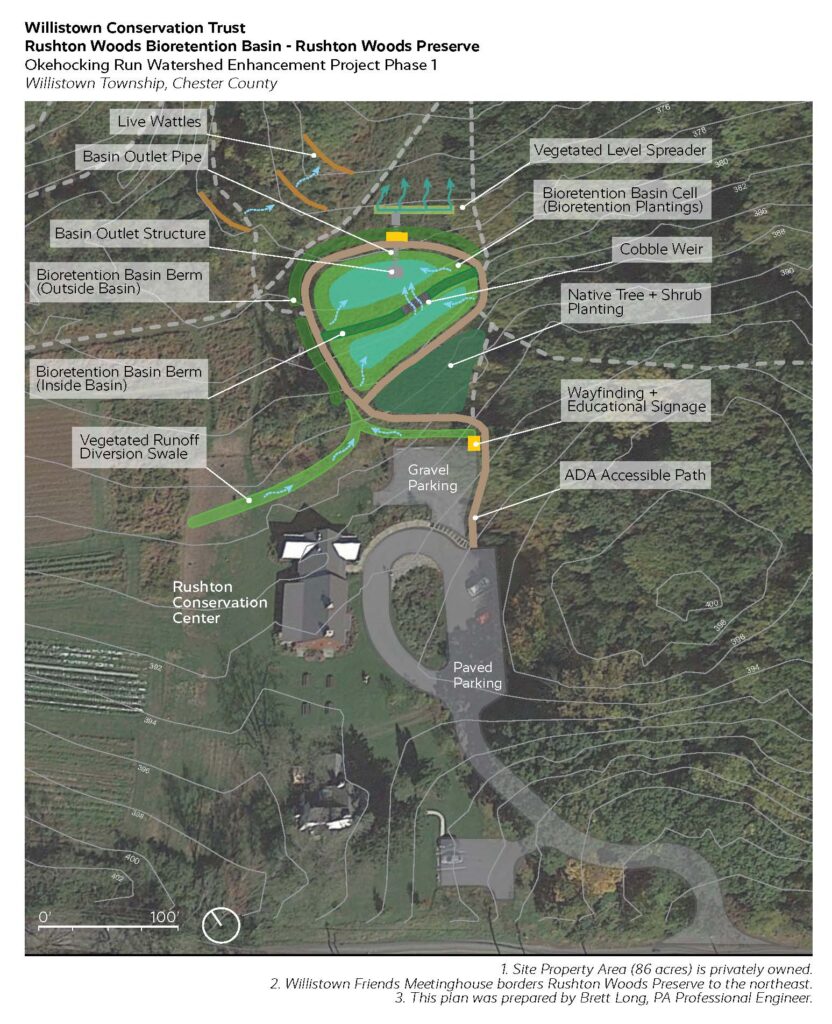
This year, WCT received a grant from the PA Department of Environmental Protection’s Growing Greener program that — combined with funding from PA Department of Conservation and Natural Resource’s C2P2 program — will pay for the design and construction of a half-acre bioretention basin with a perimeter ADA path in the field below the Rushton Conservation Center.

A bioretention basin is a green stormwater infrastructure improvement that slows down runoff and contains it behind berms filled with native plants. The stormwater collects and infiltrates slowly into the ground rather than flowing across the surface, which reduces erosion and downstream sedimentation.

The new basin, which will be constructed next year, will also provide more habitat for pollinators and birds. Filled with a variety of native plant species that tolerate periods of wetness, the basin will demonstrate to the public the benefits of combining habitat improvements with stormwater management strategies.
This spring we will construct an ADA path to connect the Rushton Conservation Center to the farm shed. This new path will provide a safe and durable surface for users of all abilities to enjoy the views of the farm and preserve. As part of the project, we will also be restoring a section of the hedgerow with native shrubs that support birds with high quality food and nesting. The project is funded by grants from Chester County and PA DCNR.

At the end of last year, we finished a trail project through the main corridor in Rushton Woods that improved the surface and stability of the trail for pedestrians and equestrians. Green Roots Inc. worked throughout an unusually wet fall and winter to lay fabric and stone aggregate to create the new tread surface. They also installed pipes underneath the trail to improve overall drainage throughout the corridor.

This was the first phase of an overall plan to improve trails at the Preserve for visitor enjoyment, safety, and accessibility. Most of the trails at Rushton were never properly designed or sited, but are the remnants of a legacy of equestrian use and fox hunting. Where the fox went, the horses followed, and thus, a trail was born. Now with the help of grant funding, we are improving our trails to deal with the increasingly intense storms resulting from climate change. Taking action now will ensure their long-term viability and accessibility for years to come.

We identified all of these projects during our Master Planning process that looked at the ecological and cultural resources at the Preserve. We then developed plans to improve these resources and amenities while increasing their sustainability and resilience for future generations.

For now, we hope you’ll spend some time exploring these new trails at Rushton Woods Preserve! See you in the woods.
Filed Under: Nature Preserves, Stewardship, Trails, Tree Planting, Volunteers

The Power of Trees in a Watershed

April 20, 2021 By Lauren McGrath

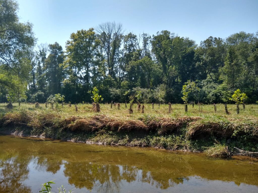
Trees that grow along waterways play a critical role in maintaining a healthy stream or river. Trees provide a huge list of benefits: from providing habitat and food to stabilizing banks and cleaning the water – trees do it all.

The Riparian Zone is the area of land that borders a waterway. This zone is very important for maintaining the health of the stream, and the trees and plants that grow in this area play a critical role in the function of a stream. Riparian trees provide a huge list of benefits: they shade the water to keep it cool, provide food and habitat, stabilize the banks of the stream and filter water to remove pollutants.

A mature leafed out canopy of a tree provides shade from the direct sunlight and keeps the water cooler. Many of the streams in this area are fed by ground water, which means that in a healthy system the water should be very cold. Cold water holds higher levels of oxygen than warm water, and as the stream water begins to warm up, oxygen levels can quickly decrease to the point that many kinds of stream life can no longer thrive. In many cases, streams can warm to the point that some stream life cannot survive. While many different things can cause a stream to warm up, one of the most obvious is a lack of riparian trees. Direct sunlight on a slow moving stream in the heat of August can rapidly warm the water, but by planting riparian trees this can be avoided.

A healthy riparian zone full of trees also provides food and habitat in the stream. In healthy headwaters or the start of a stream or river, the most important source of food is the leaves and branches that enter the waterway. This is called detritus, and is the foundation of the food pyramid. Major inputs, like the falling leaves in autumn, will feed the ecosystem through the entire winter. The leaves that fall into a stream get caught on rocks and sticks and form leaf packs, which are nutrient rich bonanzas for the stream ecosystem! For this reason, it is important that when replanting riparian areas that native plants are used, as many non-native plants do not have the same nutritional value, and will not be consumed when they enter a waterway. Trees and branches that fall into waterways also provide important cover and hiding places for many stream species. The fry, or baby fish, needs a cover to avoid being eaten by larger animals. In a natural undisturbed stream system, there would be log jams, snags, and loads of leaf packs in a waterway to provide this cover.

The canopy is not the only important part of the tree for our streams – the roots of a plant in a riparian area serve the important purpose of stabilizing the banks and slowing the rate of erosion. Erosion is a natural part of a stream’s life, but the rate of erosion can become a problem. When plants are removed from the banks, there is little to secure the soil and rocks along the edge of the waterway, and as rainfall causes water levels to rise and speed up, the force of the water begins to carry the loose bank downstream. This results in stream banks becoming steep, undercut and unstable, and large deposits occur downstream, which can smother existing stream life. Organisms like mussels can become buried underneath sediment that arrives rapidly from upstream erosion.

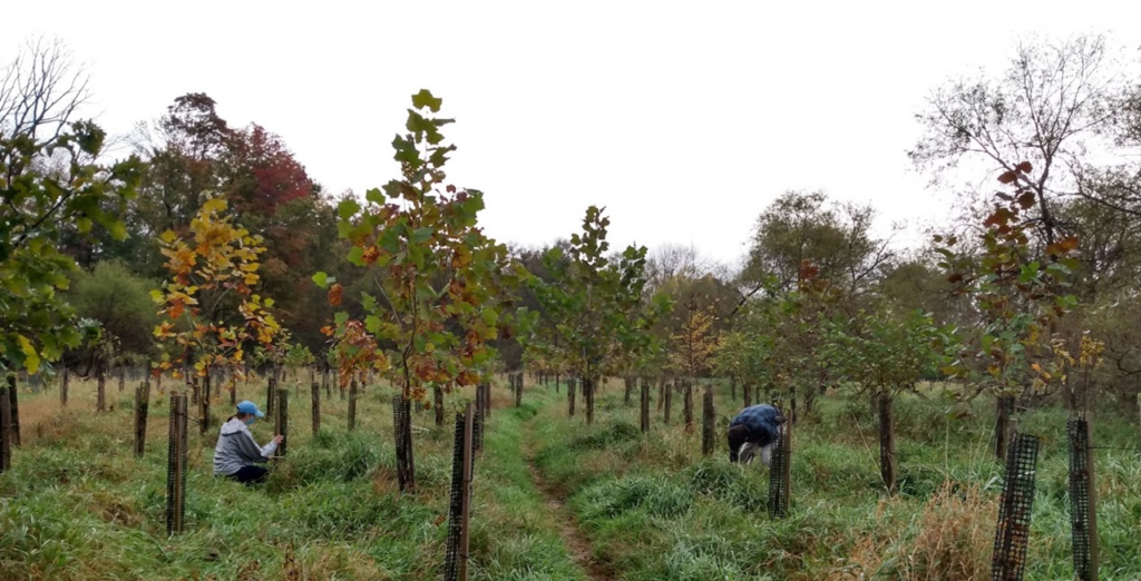
This May, the Watershed Protection Team is planting 250 trees at Ashbridge Preserve, and we need your help! Join us from May 23 through May 29 in populating the meadow at Ashbridge Lake with a diverse set of native trees and shrubs. This year, the tree planting is designed to take place over an entire week to allow for multiple small groups to come out and make a difference while staying safe and following COVID safety guidelines. We are doing our best to keep all volunteers safe while improving the habitat along Ridley Creek!


To access this year’s planting, we will need to cross Ridley Creek, so please come prepared in shoes that can get wet and muddy! Please bring your gloves and water bottles to stay hydrated during the planting.


This planting has been made possible by generous funding from the DCNR.

Filed Under: Stewardship, Tree Planting, Volunteers, Watershed

Mapping the Ashbridge Tree Planting

September 23, 2020 By Communications Team

The most important part of a tree planting usually comes after the trees are in the ground.  Recently planted trees can not be left unattended or else they will be out-competed by invasive plants or eaten by deer. Consistent tree maintenance is crucial to the survival of a young tree until it can get established in its new environment. For a tree planting in a rural setting, like the recent planting at Ashbridge Lake, maintenance includes weeding, mowing, pruning, and replacing tree tubes to keep deer from damaging the trees. Performing all of this maintenance on a tree planting with close to 1,000 trees can get complicated. Fortunately, we can use technology like a geographic information system (GIS) to help us organize tree maintenance and keep track of every tree on a site. 

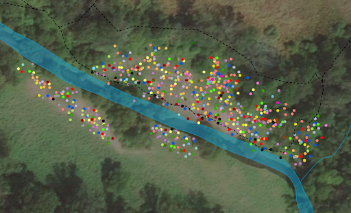
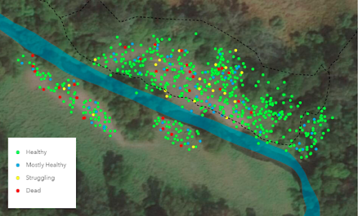
Over this past summer the Watershed Protection Team did exactly that. Using software from ArcGIS, our team mapped every tree that was planted over the last two years at the Ashbridge Lake site in Ashbridge Preserve. That is a total of 691 trees with a few hundred more set to be planted sometime in 2021. We collected the latitude and longitude of every tree and recorded the species, size, health, and date each tree was planted. We also recorded the last time each tree was maintained.  All of this data was compiled and each tree was represented with a point to create the maps shown below.

  • Trees planted at Ashbridge Lake on both banks of Ridley Creek and along the Ridley Creek Loop trail. Each color represents one of the 29 different species planted. 
  • The health of each tree was broken down into four different categories.

In addition to creating a visualization of all of the trees planted along Ridley Creek these maps create a database of information on all of our trees. Keeping track of when each tree was last maintained will help us create a streamlined maintenance system. Data on health helps us monitor the success of the tree planting and look for any unresolved problems in the planting site like areas with poor soil or frequent flooding. Measuring the size of each tree will allow us to look at growth rates to see which species are best suited for our site. All of this information is very valuable when planning for the next stage of planting at this site or for scoping out other sites that need to be reforested. 

The goal of the tree planting at Ashbridge Lake is to restore the riparian buffer along the creek which will provide habitat and food for native wildlife while improving the water quality of the stream. To achieve these goals it is necessary that as many trees as possible reach full maturity. Creating a tree map to help organize a maintenance plan and collect detailed information on each tree is one tool we can use to assure our tree planting reaches its fullest potential as soon as possible. 

This tree planting was made possible by generous funding provided by the Pennsylvania Department of Conservation and Natural Resources and TreeVitalize. See below for the full interactive map and list of species.

View larger map

EVAN HUNT joined the team as a Conservation Associate in January. Evan Hunt is a native of southeastern Pennsylvania and graduated from Ursinus College in 2018 with a BA in Environmental Studies. Since then, he has worked on a number of riparian buffer restoration projects and become well-versed in native plant identification.

Filed Under: Nature, Stewardship, Tree Planting

CONTACT

925 Providence Road
Newtown Square, PA 19073
(610) 353-2562
land@wctrust.org

JOIN OUR MAILING LIST

Copyright © 2025 · WCTRUST.ORG