WILLISTOWN CONSERVATION TRUST

  • Facebook
  • Instagram
  • LinkedIn
  • YouTube
DONATE
  • About
    • HOW WE WORK
    • WHERE WE WORK
    • OUR STAFF AND TRUSTEES
    • JOBS & INTERNSHIPS
    • RUSHTON CONSERVATION CENTER
    • STRATEGIC PLAN
    • INCLUSION, ACCESS, AND BELONGING
    • FAQs
  • LATEST
    • BLOG
    • IN THE NEWS
    • PUBLICATIONS
    • PHOTOS
  • EDUCATION
    • GROUPS
    • LAND PROTECTION
    • STEWARDSHIP
    • BIRD CONSERVATION
    • COMMUNITY FARM
    • WATERSHED PROTECTION
    • ECOCENTRIC EXPERIENCE
    • RUSHTON NATURE KEEPERS (RNK)
  • NATURE PRESERVES
    • ASHBRIDGE PRESERVE
    • HARTMAN MEADOW
    • KESTREL HILL PRESERVE
    • KIRKWOOD PRESERVE
    • RUSHTON WOODS PRESERVE
  • EVENTS
    • EVENT CALENDAR
    • BARNS & BBQ
    • RUN-A-MUCK
    • WILDFLOWER WEEK
    • ACCESS Program
  • Support
    • WAYS TO GIVE
    • SPONSOR THE TRUST
    • CORPORATE PARTNERSHIP PROGRAM
    • JOIN THE SYCAMORE SOCIETY
    • LEGACY SOCIETY & PLANNED GIVING
    • VOLUNTEER
  • OUR NEWEST PRESERVE
    • OUR NEWEST PRESERVE- KESTREL HILL

Freeze-thaw Erosion

March 17, 2025 By Sarah Barker

By: Sarah Barker

Rivers and streams are very dynamic, changing physically and chemically with every passing minute. Erosion, the process of sediment wearing away over time, plays an essential role in this endless shaping and reshaping. The movement of sediment in freshwater systems is incredibly important for water quality and habitat health. Soil binds to nutrients and salts, trapping them and preventing them from washing into streams. When severe weather events or abnormal conditions carry away large amounts of sediment these pollutants are freed into the water column, impacting wildlife and drinking water. The rate of erosion is also heavily influenced by the amount of development in the surrounding watershed. As land around a stream is developed, runoff increases and erosion worsens.

Often, erosion is considered as a consequence of storms. However, in humid, temperate climate regions like Southeastern Pennsylvania, the most influential form of erosion actually occurs in the winter, called freeze-thaw erosion. This type of erosion happens in natural cycles when extreme differences in temperature, from below freezing to above freezing, occur over a short period of time. As water freezes in the soil it expands, loosening soil particles, when it warms up suddenly after a cold spell this ice melts, creating space between particles and causing them to wear away more quickly. The impact of freeze-thaw erosion worsens after winter rain as the flow of water over already weakened banks accelerates soil loss. Development near water only makes the issue worse, providing hardened surfaces for runoff to speed into flowing water like a race track, bringing more and more loosened soil down with it. It is projected that these freeze-thaw cycles will only increase as climate change continues to modify normal weather patterns towards extremes.

Erosion on the side of a stream bank in Darby Creek.

There are other factors that can contribute to the severity and frequency of freeze-thaw cycles as well. One of the most important is the presence of vegetation along stream banks. Roots hold soil together, slowing erosion in general, however, the density of plants matter too! A 2006 study found that dense plant cover insulates banks from extreme temperature shifts over the course of a day, protecting soil from more frequent freeze-thaw cycles. Stretches of bank without dense canopy or understory were much more vulnerable to daily changes in temperature and experienced as many as four times the number of freeze-thaw cycles as densely planted sections (Wynn & Mostaghimi, 2006).

The local geology and predominant soil type of a region also significantly influence the impact of freeze-thaw erosion. Fine sediment types like clay, silt, or loam tend to be much more susceptible to this process than coarser varieties. In addition, the Piedmont region of Southeastern Pennsylvania is more heavily impacted compared to other kinds of regional geology, like the Atlantic Plain (Inamdar et al., 2018). At Rushton Woods Preserve, an ongoing erosion study documenting the progressive changes within an erosion feature called a headcut may show just how severe freeze-thaw cycles can be when these factors combine. 

Starting in June 2024, 40 pieces of  rebar, called erosion pins, were hammered into the sides of a headcut at Rushton Woods Preserve to measure the rate of soil movement due to erosion. The study area is mostly fine sediment under a canopy of beech trees, but there is sparse understory to help secure soil. Several recent freeze-thaw erosion events were documented this winter where freezing nights were followed by winter rainfall, leading to rapid movement of soil. Some erosion pins were completely buried in frozen sediment, so that they could not be measured until the next warm day. Data is still being collected, but these winter freeze-thaw measurements are already significant to the study!

Erosion is a complicated natural process, and scientists are still untangling the many mechanisms that may play a role in its impacts. However, there are some things that are very clear. Planting dense vegetation along stream banks combats severe and frequent freeze-thaw cycles. In addition, proper stormwater runoff management is vital for keeping soils stable as winter rainfalls increase in frequency. Freeze-thaw cycles themselves are normal for this area, but it is important to make sure that the rate of erosion doesn’t outpace what local streams can handle. Protecting the land around waterways is essential for healthy habitat and clean water!

References:

Inamdar, S., Johnson, E., Rowland, R., Warner, D., Walter, R., & Merritts, D. (2017). Freeze–thaw processes and intense rainfall: The one-two punch for high sediment and nutrient loads from mid-atlantic watersheds. Biogeochemistry, 141(3), 333–349. https://doi.org/10.1007/s10533-017-0417-7 

Luffman, I., & Nandi, A. (2019). Freeze-thaw induced gully erosion: A long-term high-resolution analysis. Agronomy, 9(9), 549. https://doi.org/10.3390/agronomy9090549 

Wynn, T. M., & Mostaghimi, S. (2006). Effects of riparian vegetation on stream bank subaerial processes in southwestern Virginia, USA. Earth Surface Processes and Landforms, 31(4), 399–413. https://doi.org/10.1002/esp.1252 

Filed Under: Watershed

Diatoms Illustrate How Land Use Can Alter Stream Health in Ridley Creek

October 30, 2023 By Sarah Barker

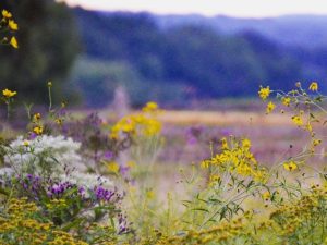
Diatoms are a single celled algae which form the foundation of stream ecosystems; they provide oxygen through photosynthesis, and act as food for other aquatic life. Diatoms are picky about where they live, with small shifts in water chemistry completely changing the species of diatoms found on a single rock. Stream conditions can change extremely quickly; a bad storm can wash away the entire diatom community, allowing new species to dominate. Changes on the landscape like development or influence from a wastewater treatment plant can also restructure diatom communities. The ability of diatom community structure to change is a wonderful tool scientists can use to investigate the health of a body of water.

Figure 1. The most abundant species across all sites except for RCWW1. Under the microscope is (a) Cocconeis pediculus (b) Rhoicosphenia abbreviata (c) Cocconeis placentula (d) Planothidium frequentissimum. 10 µm = 0.001 Centimeter.

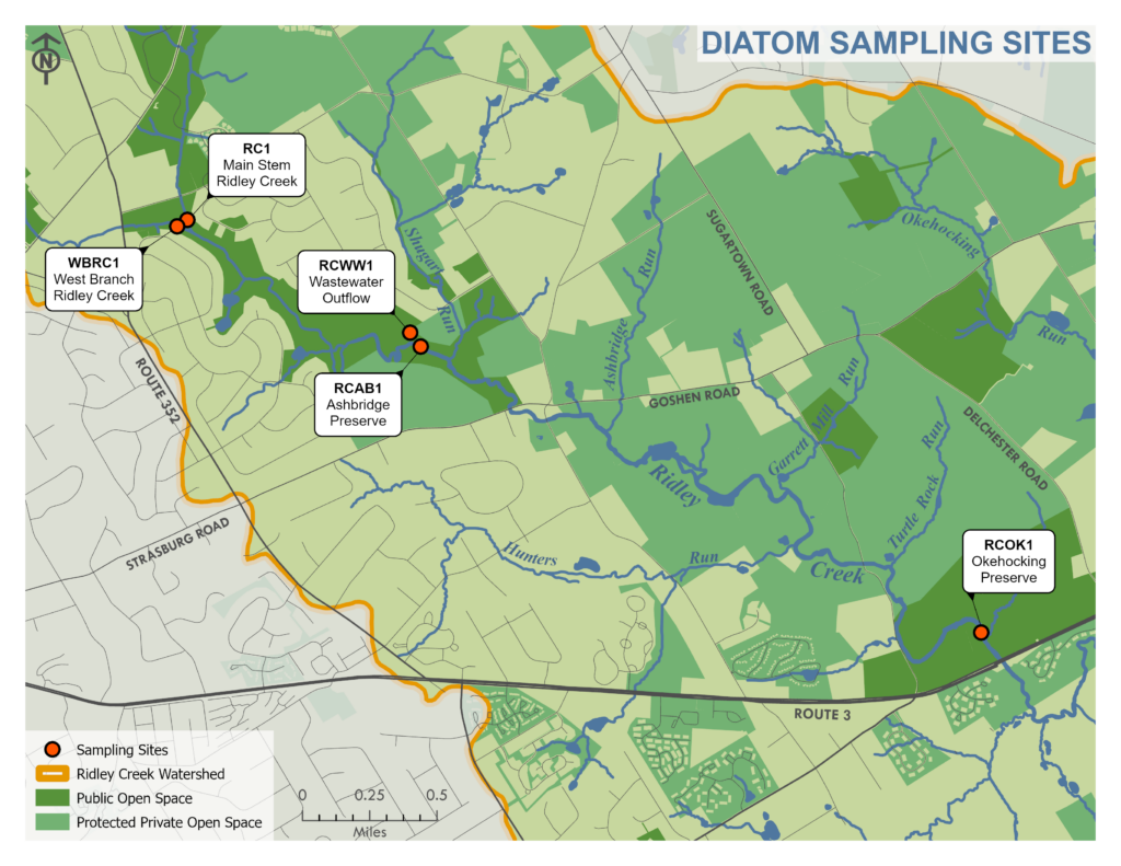
This summer, I collaborated with the Diatom Herbarium at the Academy of Natural Sciences, which hosts globally renowned diatom experts and is home to one of the oldest historical collections of diatom samples, including samples taken from Ridley Creek as long ago as 1909. With expert guidance, I collected diatom samples from five different sites along Ridley Creek (Map 1). I then worked to identify and count the most abundant species. Samples were collected from West Branch Ridley Creek (WBRC1), Main Stem Ridley Creek (RC1), a small wastewater influenced tributary that feeds into Ridley Creek at Ashbridge Preserve (RCWW1), Ashbridge Preserve (RCAB1), and Okehocking Preserve (RCOK1).

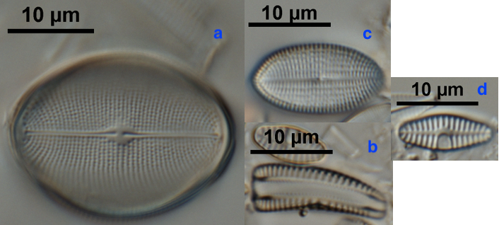
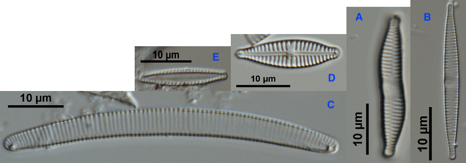
Analyzing diatom species allows us to build a baseline for what a healthy stream looks like in this geographic area. This provides a helpful benchmark that we can use in conjunction with long-term environmental data, like the water chemistry data WCT has been collecting since 2018, to study the changing health of Ridley Creek. During analysis, I counted nearly 1,400 diatom cells and found over 60 different species. Most were common freshwater diatom species, but there were a few rare species found as well. Four out of the five sites had very similar species present (Fig. 1), with the wastewater tributary showcasing a much different community structure (Fig. 2).

The four most common diatom species from West Branch Ridley Creek, Main Stem Ridley Creek, Ashbridge Preserve, and Okehocking Preserve indicate the presence of elevated nutrients in the stream. However, the most abundant species from the wastewater samples are more of a mixed bag, with some species preferring more nutrients and other species thriving in low-nutrient conditions.

Figure 2. The most abundant species from RCWW1. Under the microscope is (a) Fragilaria pararumpens (b) Fragilaria capucina (c) Eunotia bilunaris (d) Gomphonema parvulum (e) Nitzschia palea. 10 µm = 0.001 Centimeter.

There is no simple explanation for these results, but one hypothesis is that the stream conditions at the wastewater tributary are less stable, leading to rapid changes in habitat for diatoms, causing populations to fluctuate. In contrast, the other four sites are more likely to have a relatively stable environment, allowing species that share similar optimal habitats to establish robust populations.

Diatom diversity in general, is correlated with conductivity, which is a broad water quality measurement that reflects the presence of ions, including pollutants like salts and nutrients, in the water. The different ions that are measured by conductivity matter when it comes to where certain species will thrive. Conductivity was measured at each sampling site at the time of sampling, and the wastewater tributary was found to have the highest conductivity of all sites by a significant margin. Such a difference in conductivity between the wastewater tributary and the other sites along Ridley Creek, suggests that despite being close geographically, the difference in habitat supports a completely different community
of diatoms.

The wastewater tributary is an example of how development can negatively impact water quality, resulting from the presence of a wastewater treatment plant. With this data, we can begin investigating why diatom communities change, start to understand what a healthy diatom community looks like in Ridley Creek, and work to continue the decades-long effort by the community to protect and restore these precious stream habitats.

Sarah Barker | Sarah is a senior at Drexel University where she is majoring in Biology with a concentration on evolution, ecology, and genomics. Before joining the Watershed Program, she spent six months working for a water quality start-up called Tern Water as a water chemistry research/lab assistant and another six months working at Polysciences as a quality control chemist. As a Watershed Protection Program Co-op, her responsibilities included assisting in sample collection, equipment maintenance, data collection and entry, running laboratory analyses, and aiding in educational outreach.

Filed Under: Uncategorized

CONTACT

925 Providence Road
Newtown Square, PA 19073
(610) 353-2562
land@wctrust.org

501(c)(3) EIN 23-2841453

JOIN OUR MAILING LIST

Copyright © 2026 · WCTRUST.ORG