WILLISTOWN CONSERVATION TRUST

  • Facebook
  • Instagram
  • LinkedIn
  • YouTube
DONATE
  • About
    • HOW WE WORK
    • WHERE WE WORK
    • OUR STAFF AND TRUSTEES
    • JOBS & INTERNSHIPS
    • RUSHTON CONSERVATION CENTER
    • STRATEGIC PLAN
    • INCLUSION, ACCESS, AND BELONGING
    • FAQs
  • LATEST
    • BLOG
    • IN THE NEWS
    • PUBLICATIONS
    • PHOTOS
  • EDUCATION
    • GROUPS
    • LAND PROTECTION
    • STEWARDSHIP
    • BIRD CONSERVATION
    • COMMUNITY FARM
    • WATERSHED PROTECTION
    • ECOCENTRIC EXPERIENCE
    • RUSHTON NATURE KEEPERS (RNK)
  • NATURE PRESERVES
    • ASHBRIDGE PRESERVE
    • HARTMAN MEADOW
    • KESTREL HILL PRESERVE
    • KIRKWOOD PRESERVE
    • RUSHTON WOODS PRESERVE
  • EVENTS
    • EVENT CALENDAR
    • BARNS & BBQ
    • RUN-A-MUCK
    • WILDFLOWER WEEK
    • ACCESS Program
  • Support
    • WAYS TO GIVE
    • SPONSOR THE TRUST
    • CORPORATE PARTNERSHIP PROGRAM
    • JOIN THE SYCAMORE SOCIETY
    • LEGACY SOCIETY & PLANNED GIVING
    • VOLUNTEER
  • OUR NEWEST PRESERVE
    • OUR NEWEST PRESERVE- KESTREL HILL

Welcome to Willistown Conservation Trust’s 2022 Creek Week Sponsored by Aqua!

June 20, 2022 By Lauren McGrath

Established in 2017 through a generous grant from the William Penn Foundation, the Watershed Protection Program Team has been working to monitor the health of the Ridley, Crum, and Darby Creek Watersheds. One of the main goals of the Watershed Program is to study and understand how human activities on the landscape are connected to the function of local streams.

For this year’s Creek Week, we will be sharing information about bogs and wetlands; beavers and stream insects; dragonflies, freshwater mussels, and a case study of water chemistry in Ridley Creek. Each of these topics is inspired by what we have observed during our time in these beautiful watersheds, and highlight the intricate relationships between our soil, air, and water systems.

Kirkwood Crum Creek | Photo by Jennifer Mathes

This Creek Week is not just online! The Watershed Team will be at Ashbridge Preserve on Thursday, June 23 and Saturday, June 25. We welcome volunteers of all ages and abilities to join us as we work to maintain the Ashbridge Tree Planting area! This planting was generously funded by the PA DCNR, and since 2019, we have planted over 1,200 trees along Ridley Creek within the preserve.

The trees along Ridley Creek help keep the water cool, slow and filter stormwater, keep the banks of the stream stable and provide important food resources to power the base of the stream food chain, which extends far beyond the waterway. The insects that rely on the leaves and branches from the banks go on to feed fish, mammals, and birds. Insects that emerge from waterways over the course of the spring fuel migratory and hatchling songbirds! With insect populations declining across the country, it is critical to understand where these insects live and how we can make sure they have the habitat and food they need to thrive.

Photo by Jennifer Mathes

As caretakers of the origin, or headwaters, of the Ridley, Crum, and Darby Creek stream systems, we have an opportunity to provide healthy water for everyone downstream of us — humans and wildlife alike! Both Ridley and Crum Creeks are potential drinking water sources for thousands of residents in Delaware County, and we are thrilled to have Aqua, an Essential Utilities Company, as a sponsor for this year’s Creek Week! We hope to see you on Friday, June 24, at our Community Supper Series, where you can learn more about the amazing water resources in our region.

Please enjoy this week-long sampling of lessons from the streams. The aquatic environment is a dramatic, wonderful, and ancient world full of resilience and hope. Each of us in the Watershed Program is thankful for the opportunity to share what we have been learning, and we welcome your curiosity and questions!

Filed Under: Nature, Watershed

The Trust Teams up with Project Plastic at Ashbridge Preserve to Clean Up Microplastics Using Innovative Device: The Plastic Hunter

February 1, 2022 By CommIntern

Last year we learned that Microplastic Pollution is No Small Problem, after our Watershed Protection Program discovered the dangerous presence of these minute plastics within the headwaters of our focus area: Crum, Darby and Ridley Creeks. Our Watershed Team continues to document and monitor their presence, but now with the help of Project Plastic.

Based in Princeton, New Jersey, Project Plastic is made up of Princeton students and postdoctoral researchers working to design, develop and implement natural systems that can be used to remove plastic pollutants from rivers. Founder Yidian Liu was inspired to find a solution to plastic pollution after observing an increase in the presence of plastics and microplastics gathering in the waterways following large storms in her hometown in China. Now, with Project Plastic, it is her goal to create the first portable microplastic collection device that is both easily portable and environmentally friendly.

Enter the “Plastic Hunter,” an “affordable floating wetland unit that collects and removes microplastic debris from rivers via plant root biofilters.” Resembling an elongated hexagon, this device consists of a fiberglass frame that holds a net-like pad that is both compostable and consisting of a planting membrane. This is where the magic happens – once deployed on the surface of a polluted river, the plant membrane grows downward, and over time, its dangling roots catch microplastic fragments. Once saturated, the removable planting membrane is carefully lifted from the water with a net, and the contaminated plant matter can be taken back to the lab for analysis. A new pad replaces the old one, and the microplastic-trapping cycle continues.

  • Plastic Hunter’s natural fibers and root system catch microplastics
  • Removing Plastic Hunter
  • A Root Sample Retrieved for Analysis

Conceived and developed by Yidian Liu and Nathaniel Banks, this device and Project Plastic have already received attention after winning multiple awards, including a $10,000 prize for top startup at the Princeton Startup Bootcamp.  They have since added to their team, refined their idea, filed a patent, and made multiple design improvements using 3D print prototypes. And then this past December and January, Project Plastic officially launched the very first Project Hunter prototype at Ashbridge Preserve with the help of our Watershed Protection Team.

Thanks to the continual monitoring of our watersheds, Watershed Protection Program Director Lauren McGrath identified a test site known to be highly contaminated with microplastics at Ashbridge Preserve. Plastic Hunter lived here for one month, where it was anchored to stakes located on either side of the stream, covering the majority of the stream’s width. And in place of a true plant membrane, an artificial root system comprised of coconut fiber brushes was used to entrap microplastics, essentially acting as a filtration device.

  • Project Plastic and WCT at Ashbridge Preserve
  • Plastic Hunter Up and Running at Ashbridge Preserve

Throughout Plastic Hunter’s stay at Ashbridge, Lauren McGrath and Watershed Conservation Associate Anna Willig collected water samples around Plastic Hunter on a weekly basis to determine if the device had reduced microplastic quantities within the stream. Once Plastic Hunter was removed from the stream, its fibers were taken by to Project Plastic’s lab for analysis, and there, the team found that their prototype was mostly effective in capturing microplastics.

  • Water Samples for Analysis
  • Processing of the Water Samples
  • Microplastic Fiber Identified under a Microscope

Says Yidian Liu, “The Ashbridge Preserve field test marks a prospective start to the development and continued refinement of the Plastic Hunter, as well as an auspicious confirmation of the device’s technical feasibility and efficacy. We are looking forward to continuing to improve this device with the help of the Trust’s Watershed Team.” The group hopes to make Plastic Hunter more buoyant with increased connectivity between those fibers and the device’s frame.

The vision for this group is to deploy future generations of Plastic Hunter across rivers, ponds, and other bodies of water, where their hexagonal frames can connect to one another to create larger filtration devices. Yidian and Nathaniel aim to keep costs as low as possible, so that their product can be affordable and reach a variety of customers across the world. And by focusing on using compostable, natural materials, they hope to also reduce the cost to our planet.

Says the Trust’s Watershed Protection Program Director Lauren McGrath, “Globally, microplastic contamination is a major concern for public and environmental health, and identifying meaningful solutions for the reduction and removal of plastic from stream and ocean systems has been a serious challenge. We have enjoyed partnering with the Project Plastic Team and are inspired by their creative and innovative approach to this increasingly complex issue. We hope that through regular monitoring and creative problem solving, we can continue to better understand how to reduce microplastic pollution in our waterways.”

Visit Project Plastic to learn more about their plastic-free vision for the future!

Filed Under: Science, Watershed

Beaver Business

January 4, 2022 By Anna Willig

Please Note: The Watershed Protection Team is excited to welcome our newest team member and encourages all visitors to keep an eye out for beavers at Ashbridge but please do not go searching for them. The health of our waterways will benefit from the presence of Castor canadensis, so please be respectful of their space.  

In the middle of the 2021 spring tree planting, the Watershed Protection Team had quite the surprise when we spotted evidence of beaver activity in Ashbridge Preserve. A single tree was knocked down along Ridley Creek, with distinctive teeth marks that indicated a beaver had found itself a tasty meal. In October, the first lodge was located, and it was clear that the beavers had settled in the center of 1,000 freshly planted trees. But more than concern was a feeling of validation; the hard work of every staff member, volunteer and student has resulted in the creation of suitable habitat for one of nature’s most effective ecosystem engineers.

  • A beaver caught on the Trust’s wildlife cam
  • Evidence of beaver activity at Ashbridge Preserve. Photo by author.

Beavers (Castor canadensis) are the largest rodent found in North America, reaching 3 feet in length and weighing between 30 and 60 pounds. They have small faces, stocky brown bodies, and a distinctively hairless, paddle-shaped tail. Their tail allows beavers to be distinguished from groundhogs, which have short, furry tails, and muskrats, which have long, hairless tails. Beavers are well-adapted for an aquatic lifestyle: when they dive underwater, their eyes are protected by a set of transparent eyelids and their ears and nose are protected by watertight membranes. They even have a second set of lips that close behind their teeth, which allows them to chew while underwater and not drown. They can remain underwater for 15 minutes, and their oily, waterproof fur helps them stay dry. Their webbed feet and rudder-like tail allows beavers to swim at speeds of 5 miles per hour.

Chompy the beaver was donated to Willistown Conservation Trust and currently lodges in the Rushton Conservation Center. Note its glossy fur and hairless, paddle-shaped tail. Photo by author.

Beavers were once abundant throughout North America, from northern Mexico all the way up to the southern Arctic. However, they were heavily hunted for their waterproof pelts by European colonizers, and their numbers dropped rapidly. In Pennsylvania, beavers were wiped out by the beginning of the 20th century. Reintroduction efforts in the 1920s proved successful, and beaver populations have been stable in Pennsylvania since the 1930s, though they likely are not as abundant as they were before European colonization. There are a few known beaver colonies near Willistown in Ridley and Darby creeks, and evidence of beaver activity is occasionally spotted in Willistown, most recently at Ashbridge Preserve.

Beavers are perhaps nature’s most effective engineers, changing entire ecosystems to fit their needs. They build their homes, called lodges, almost exclusively in the middle of slow-moving ponds, where the surrounding water acts as a moat that protects them from terrestrial predators. If no such pond can be found, beavers dam streams and rivers to create the perfect pond. To create their dams, beavers cut down trees with their chisel-like teeth, which constantly grow and self-sharpen. They generally prefer trees with diameters of less than 3 inches, but will cut down larger trees if small trees are not readily available. They construct their dam with logs, branches, twigs, and grasses and seal everything into place with mud. 

Once the dam backs up enough water, beavers build wood and mud lodges in the middle of the pond that can be 6 feet high and up to 40 feet wide. These lodges have 1 or 2 underwater entrances, a ‘living area’ above the water line, and a small air hole in the top to provide ventilation. A lodge houses a colony made of a breeding pair — believed to mate for life — the current years’ kits, and the surviving offspring from the year before. Before the kits are born, the female drives out the second year young. After the young are driven out from the den, they disperse to find new habitat and form their own colonies. 

Beaver settlement causes widespread changes to an ecosystem. The first noticeable change is the clearing of several trees, usually small, that the beaver will use to build its dam. After the dam is built, the creek will start to back up, flooding the adjacent land and forming a small pond. More trees may be felled to build the beaver’s lodge. What was once a wooded valley with a small stream becomes an open pond bordered by wetland vegetation. This new pond supports a host of wetland species that would not otherwise be found in the area — ducks, geese, herons, turtles, fish, frogs, salamanders, and more. Even beaver lodges create habitat: the underwater base of the lodge provides shelter for young fish and the top of the lodge can be a nesting area for birds. 

A beaver captured on the Trust’s game cam

Beyond supporting a biodiverse ecosystem, beavers and their dams improve local water quality. Beaver ponds trap and slow down water, reducing downstream flooding during major storm events. By slowing down the flow of water, beaver dams also allow more water to seep through the soil and replenish groundwater resources. As water passes through a beaver pond, fine sediment and pollutants are filtered out, resulting in cleaner water downstream of the dam. 

Beavers inhabitat a pond until they deplete all nearby food sources, usually after 20 to 30 years. At this point, they abandon their pond and lodge and move on to new habitat. Without constant maintenance, the dam slowly breaks down and eventually breaches. The pond drains, and the previously-submerged seed bank begins to germinate. Shrubs and trees re-establish in the area and, eventually, the open land turns back into a wooded valley. 

If you want to learn more about the history, biology and benefits of having beaver living in local streams, join us for our upcoming virtual Beaver Talk on February 2!

References

Beaver. (n.d.). Pennsylvania Game Commission. Retrieved May 27, 2021, from https://www.pgc.pa.gov:443/Education/WildlifeNotesIndex/Pages/Beaver.aspx

Beaver. (2016, April 25). Smithsonian’s National Zoo. https://nationalzoo.si.edu/animals/beaver

Beaver | National Geographic. (n.d.). Retrieved May 27, 2021, from https://www.nationalgeographic.com/animals/mammals/facts/beaver

Wohl, E. (2021). Legacy effects of loss of beavers in the continental United States. Environmental Research Letters, 16(2), 025010. https://doi.org/10.1088/1748-9326/abd34e

Filed Under: Nature Preserves, Science, Watershed

A Macroinvertebrate’s Thanksgiving Feast

November 16, 2021 By Anna Willig

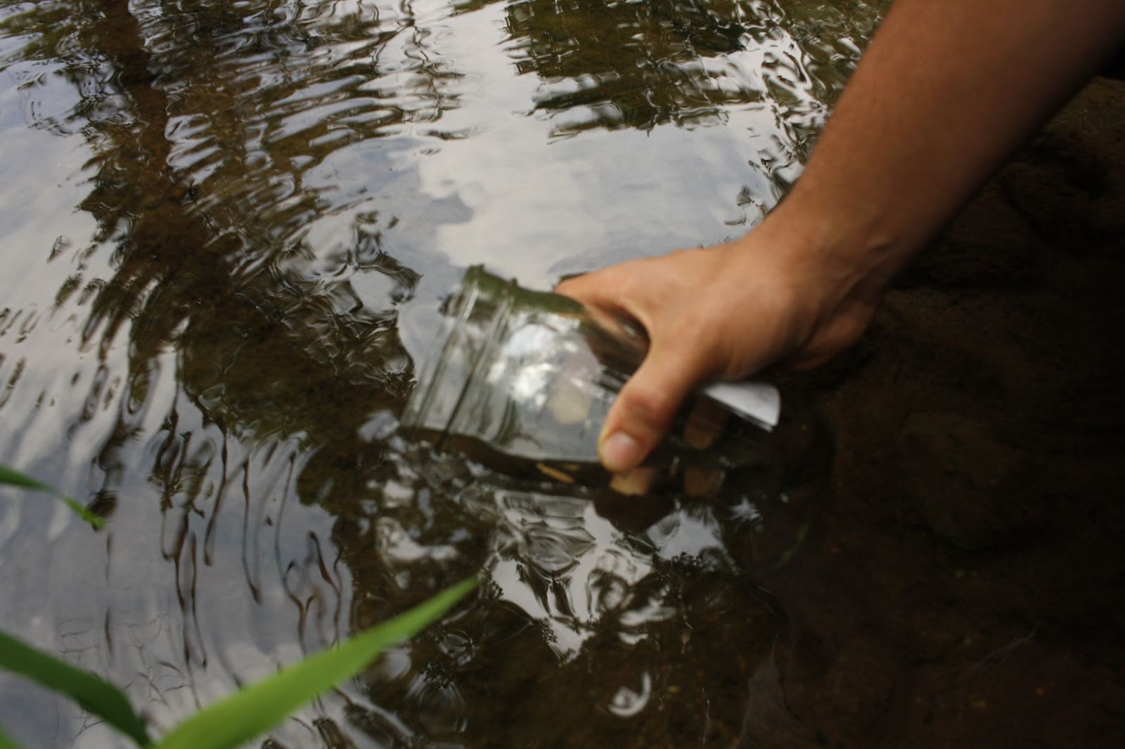
Each fall, trees provide a veritable Thanksgiving Feast for aquatic macroinvertebrates. They spend the whole spring and summer preparing this feast, growing it, maintaining it, making sure everything is just right, and, come fall, dropping it all in the stream. What is this feast? Leaves!

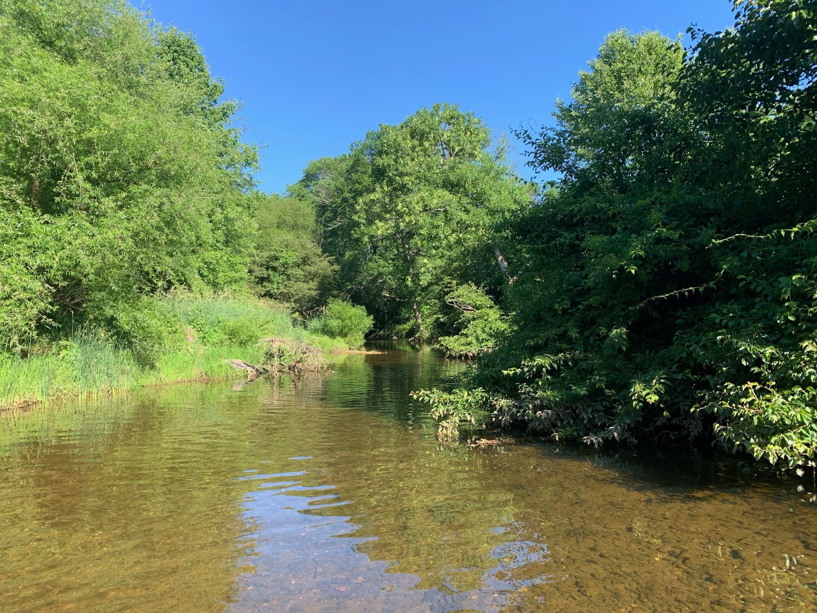
Leaves from trees and shrubs are a form of allochthonous input, or something that enters an ecosystem from outside of the system. In small headwater streams, such as those found in our area, allochthonous input is a dominant source of energy, essentially forming the base of the food chain. Generally, these small headwater streams are forested, preventing light from reaching streams, inhibiting photosynthesis, and thus limiting the growth of aquatic plants. Consequently, the main source of energy in these streams comes from trees in the form of fallen leaves.

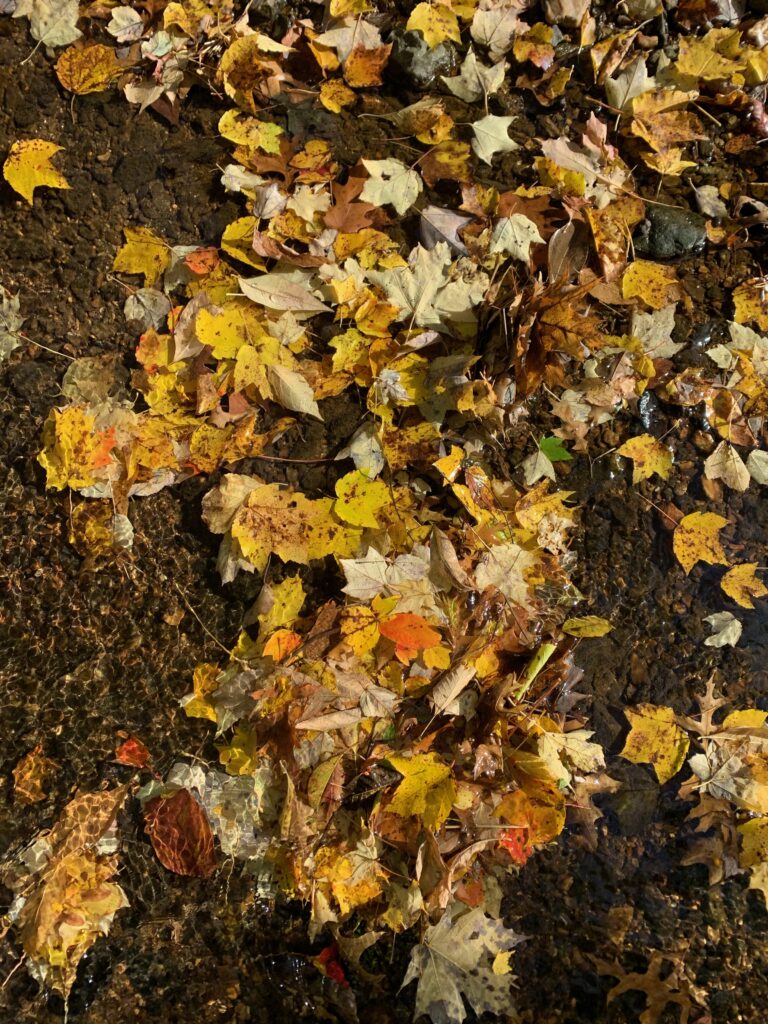
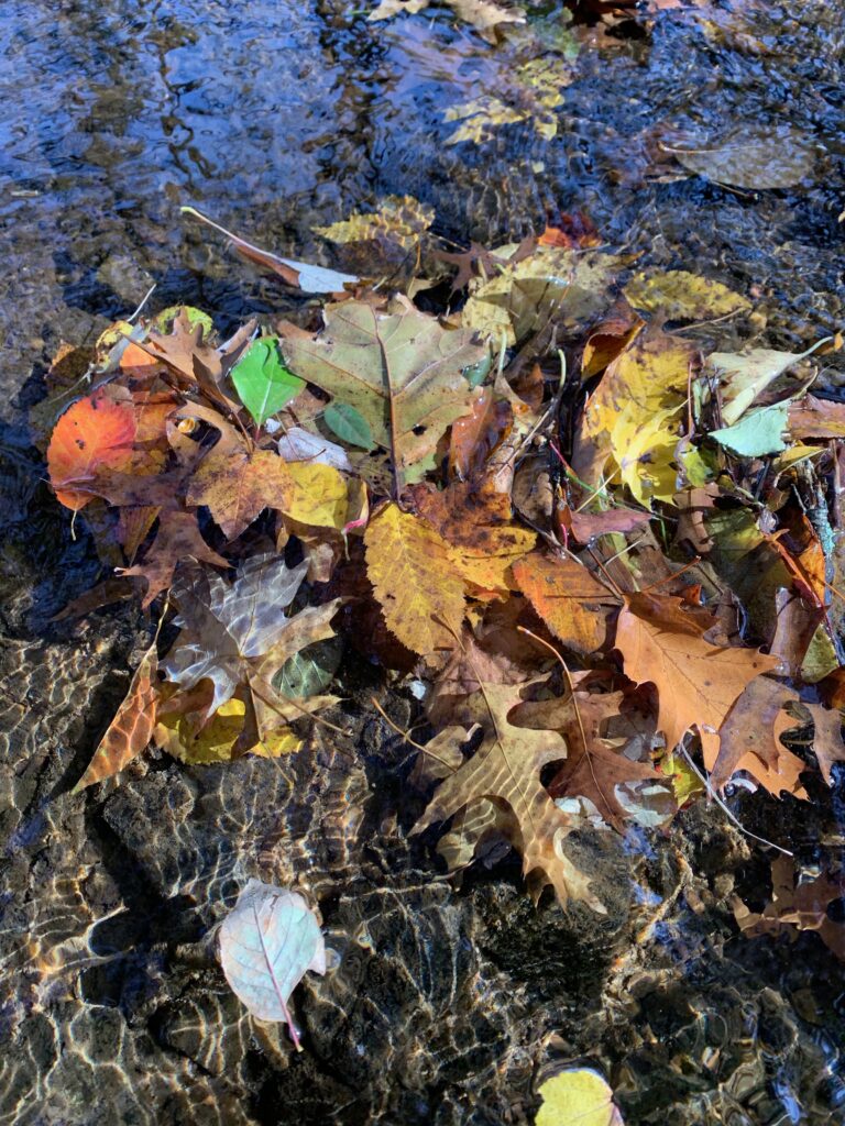
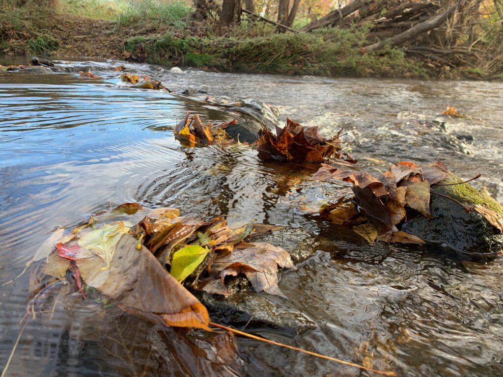
Once leaves fall into the stream, microbes, such as bacteria and fungi, colonize leaves, starting the process of decomposition. Some macroinvertebrates, called shredders, eat the leaves themselves, feasting on the plant material. Other macroinvertebrates, called scrapers, eat the layer of algae, bacteria, and fungi that develops on fallen leaves. Both shredders and scrapers are eaten by predatory macroinvertebrates, which are in turn eaten by frogs, salamanders, fish, and other aquatic animals, moving energy up the food chain.  

Leaf litter in streams also provides important habitat for macroinvertebrates. Smaller macroinvertebrates can hide from predators in the leaf litter, while predatory macroinvertebrates can hide from unsuspecting prey in the leaf litter as well. 

Since leaf litter is so important for macroinvertebrate communities, any changes to the amount and type of leaf litter that reaches the stream can impact the macroinvertebrate community. In areas where trees have been cleared along stream banks, the primary energy input is no longer leaf litter. Rather, since sunlight can reach the stream, aquatic algae and vegetation will grow more readily and become the dominant source of energy. As a result, the macroinvertebrate community will shift to a community that primarily eats aquatic vegetation and algae, with consequences for the entire food chain. Similarly, if the composition of riparian vegetation changes and non-native plants become more common than native plants, the macroinvertebrate community may shift as well. 

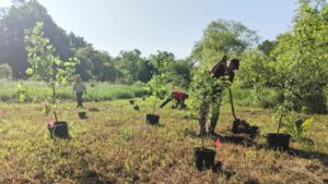
The best way to maintain and improve this Thanksgiving Feast for our aquatic life is to protect forests along streams, remove invasive species, and plant native trees along streams. Willistown Conservation Trust is working to enhance this feast at Ashbridge Preserve, where we have planted over 1000 trees along Ridley Creek. We hope that these trees will improve water quality and contribute much needed allochthonous input for the inhabitants of Ridley Creek.

By Anna Anna Willig | she/her | Watershed Conservation Associate | As part of our Watershed Protection Program, Anna assists with monthly water chemistry sampling, maintains the tree planting at Ashbridge Preserve, and analyzes water quality data from sampling and from our EnviroDIY sensors.

Filed Under: Amphibian conservation, Nature, Science, Watershed

Flooding 102

August 30, 2021 By Anna Willig

Flooding 102

Last week we looked at the basics of flooding, learning about what constitutes a flood and how floods are measured. This week, we wanted to dive deeper into flooding and explore the causes of floods and how flooding in our area looks different today than it did 20 years ago. If you didn’t get a chance to read our last article, check it out here. 

Where does flooding happen?

When we think about flooding, we are often concerned less by the amount of water moving through a stream and more by the land that becomes inundated with water. The area covered by water during a flood is called a floodplain. Floodplains tend to be flat, low-lying areas adjacent to streams and rivers. Not all floods will cover the entire floodplain, and some floods are large enough to reach areas above the usual floodplain. Since the size of a flood impacts the area that will be flooded, we can expect that a 100-year floodplain, the area that will be inundated during a 100-year flood, to be smaller than a 500-year floodplain. 

How much rain do you need to cause a flood? 

The amount of rain needed to cause a flood depends on many factors. The amount of rain that falls during a storm is not the same as the amount of water that reaches a stream. When water falls in a watershed, it can either be absorbed into the soil, a process called infiltration, or it can flow over the ground into the stream, a process called runoff. In general, more runoff leads to more flooding. 

A big factor that determines the amount of runoff from a rainfall event is the amount of impervious surface in a watershed, the area that feeds into a stream. An impervious surface is any feature that blocks water from infiltrating into the soil, such as buildings, roads, parking lots, driveways, sidewalks. Watersheds with lots of impervious surfaces will have more runoff than watersheds without impervious surfaces. Consequently, more water from a storm will reach the stream in watersheds with more impervious surface cover, causing greater flooding than if there were less impervious surface cover. 

Recent weather conditions also impact the amount of rain needed to cause a flood. Soils can only absorb so much water before they are saturated and cannot absorb any more. If a storm occurs after a few rainy days, when the soils are nearly saturated, less water will infiltrate and more water will run off, causing a larger flood than if the same storm occurred during a dry period. 

The rate of rainfall also impacts flooding. Storms that dump a few inches of rain in an hour will cause more flooding than storms that have the same amount of rain over several hours. Infiltration of rainwater into soil takes time, so more water will be able to infiltrate when a storm occurs over a longer period of time, resulting in less runoff and less flooding.

What is the difference between a flood and a flash flood?

Flash floods are a type of flood that occur quickly, within a few minutes to a few hours of a heavy rainfall. They are marked by a sudden increase in water level and are most common in developed areas with lots of impervious surfaces where there is little infiltration. Flash floods are generally considered the most dangerous type of flood because they can occur with little warning, leaving people little time to evacuate the floodplain.

It seems like we are having 100-year floods every year, why is that? 

In our last post, we discussed that a 100-year-flood was a flood that had a 1% chance of occurring in any given year. However, changes in our watersheds and in our climate are altering flood patterns in our area. 

The amount of impervious surface in a watershed is a major factor in determining how big a flood will be after any given rainstorm. As our area becomes more developed and more impervious surfaces are put in, it takes less and less rain to cause a flood. 

Climate change impacts the frequency and intensity of storms and resulting floods in our area. Researchers predict that a warming planet will cause larger and more frequent hurricanes to form in the Atlantic Ocean. While the brunt of the damage from these storms will be borne by coastal communities, we can expect to see more of these storms reaching our areas, leading to large floods such as those caused by Tropical Storm Isaias in 2020, Tropical Storm Sandy in 2012, Hurricane Irene in 2011, and most recently, Hurricane Ida.  

In addition to seeing the consequences of more severe coastal storms, our area is predicted to see an increase in annual precipitation by 2050. As a result, we can expect to have more intense storms more frequently. The increase in intensity and frequency of these storms, combined with the increase in impervious surfaces in our watersheds, means that what was once a 500-year flood may now be considered a 100-year flood and what was once a 100-year flood may now be a 50-year or a 20-year flood.

What is Willistown Conservation Trust doing to reduce flooding? What can I do?

Protecting land from development is one of the best ways to combat flooding. Land that is undeveloped allows far more infiltration than land that is developed, reducing the amount of runoff that reaches our streams after a rainstorm and the resultant floods. 

In addition, the Watershed Protection Program has planted over 800 trees along a floodplain at Ashbridge Preserve. Planting trees helps increase the amount of water that infiltrates into soil and will eventually reduce flooding downstream.

You can help too! Letting your grass grow a little taller before mowing is a great way to increase the amount of water that your yard can absorb, thereby reducing runoff. Adding a rain garden with native plants to your yard reduces the amount of water that runs off into streams. You could also add a rain barrel to your yard and collect rainwater for later use in your garden or elsewhere. Any action you take that reduces the amount of runoff reaching streams will make a difference in flooding for all those living downstream.

To learn even more about flooding, check out these resources:

  • See if you live in a floodplain using FEMA’s interactive Flood Map: FEMA Flood Map Service Center: Search By Address 
  • Learn more about the impacts of climate change on Pennsylvania: Pennsylvania Climate Impacts Assessment 2021
  • Explore how you can reduce runoff from your home: What You Can Do to Soak Up the Rain

Filed Under: Watershed

  • « Previous Page
  • 1
  • …
  • 5
  • 6
  • 7
  • 8
  • 9
  • …
  • 14
  • Next Page »

CONTACT

925 Providence Road
Newtown Square, PA 19073
(610) 353-2562
land@wctrust.org

501(c)(3) EIN 23-2841453

JOIN OUR MAILING LIST

Copyright © 2026 · WCTRUST.ORG